Thailand’s military is attempting to produce a new map to incorporate areas it has “invaded and is illegally occupying” into Thai territory, a senior Cambodian border official said, while maintaining that historical boundary documents and even Thailand’s own maps place Khnar and other ancient temples along the Dangrek Mountains inside Cambodia.
Speaking in an interview on border affairs, Ith Sotha, Permanent Secretary of State at the State Secretariat of Border Affairs (SSBA), said the Cambodia-Thailand border had already been legally established through treaties, conventions, maps, and boundary markers dating back to the early 20th century.
“The Cambodia–Thailand border is an international boundary established in the early 20th century through boundary delimitation and the placement of 73 boundary markers,” he said. “This process was based on conventions, treaties, maps, boundary pillar records and other related documents, as well as physical demarcation on the ground.”
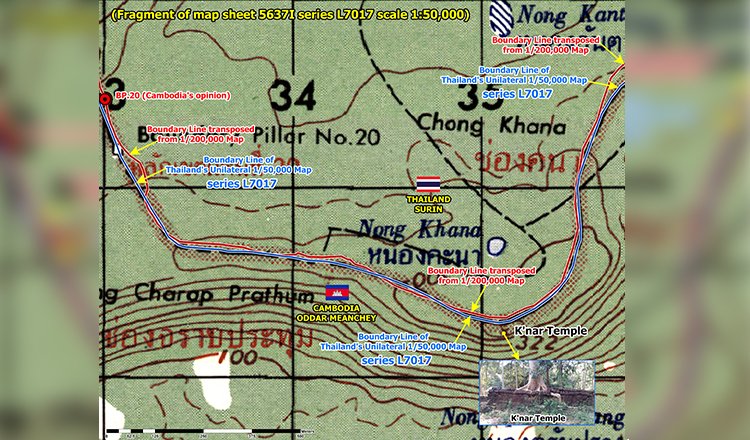
Sotha said Khnar Temple falls within Cambodian territory under the official 1:200,000-scale map produced by the Franco-Indochina-Siam Boundary Delimitation Commission.
Using satellite imagery during the interview, Sotha said both Cambodia’s interpretation of the boundary and Thailand’s own unilaterally produced 1:50,000-scale map place the temple inside Cambodia.
“The temple’s location can clearly be seen on this current satellite image,” he said. “Therefore, both boundary lines—the Cambodian position shown in red and the Thai position shown in blue—indicate that the temple lies within Cambodia’s sovereignty.”
He further argued that Thailand’s L7017 map, despite being produced unilaterally, also supports Cambodia’s claim. Sotha said the Thai military is attempting to redraw the border.
“At present, to my knowledge, the Thai military is attempting to draw a new boundary line to incorporate areas that Thailand has invaded and is illegally occupying into Thai territory,” he said.
He added that any maps produced unilaterally by Thailand have no legal standing.
“Regardless of the L7017 map used by Thailand, or any other maps that Thailand has produced or drawn unilaterally, those maps have no legal validity or legal effect,” he said.