He Uruguayan Institute of Meteorology (Inumet) issued a special notice for a period of instability that will start this Tuesday, May 5 in the afternoon and will last for several days, with strong storms, intense rains, winds and subsequent formation of an extratropical cyclone.


According to the agency, during the afternoon and evening of this Tuesday, storms, some occasionally strongmainly in the north and central strip of the country. These phenomena may be accompanied by intense gusts of wind and abundant rainfall in short periods, with accumulations of between 20 and 40 millimeters in three hours.
Heavy rain and severe storms since Wednesday
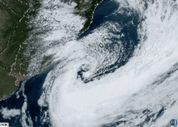
Between the night of Wednesday the 6th and the early hours of Friday the 8th, a cold front will enter the country and cause strong storms—some severe—and abundant rains throughout the territory.
More news
During this period, significant accumulations of precipitation are expected, between 60 and 100 millimeters in 12 hours, especially in the center-south, east and northeast. During storms there may be intense electrical activity, heavy rain, very strong gusts of wind and occasional hail.
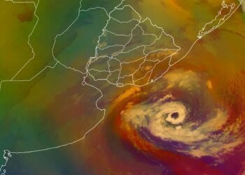
Strong winds, extratropical cyclone and low thermal sensation towards the weekend
Starting Friday the 8th and until the morning of Sunday the 10thafter the passage of the cold front, an increase in wind intensity is expected due to the deepening of a extratropical cyclone over the Atlantic Ocean.
The phenomenon will mainly affect the coastal zonewith persistent strong to very strong winds and a significant increase in waves. In addition, a marked drop in temperature is expected, with low thermal sensations.
Inumet recommended following updates to its forecasts and eventual alerts through its official channels.
He meteorologist Nubel Cisneros had warned about the formation of an extratropical cyclone that would begin to develop on Wednesday night with rain and storms, and that will have its greatest impact between Friday and Saturday.
As indicated, winds of 60 to 80 km/h are expected – with higher gusts in the east – and a marked drop in temperature, with maximums of 12° to 14° and thermal sensations close to 0°C or lower. Thursday will be rainy due to the passage of a cold front, while on Sunday conditions will improve with the presence of sun.