A combination of an extratropical cyclone, a cold front and a cold air mass conditions the weather in the Southern Cone and maintains low temperatures in Uruguayaccording to an analysis published by the Brazilian meteorological agency Metsul.
Although the cyclone is located over the South Atlantic and does not represent a direct risk for Uruguaythe system drives a mass of cold air that favors a marked decrease in temperatures in the region.
Uruguay recorded temperatures below zero
According to Metsul, Uruguay once again registered temperatures below zero during the last hours. The minimum notable was -0.7°C in Trinidadin the department of Flores.
The cold air was also felt in Argentina, where the Ezeiza international airport, in the Buenos Aires metropolitan area, recorded a minimum temperature of 1.6°C.
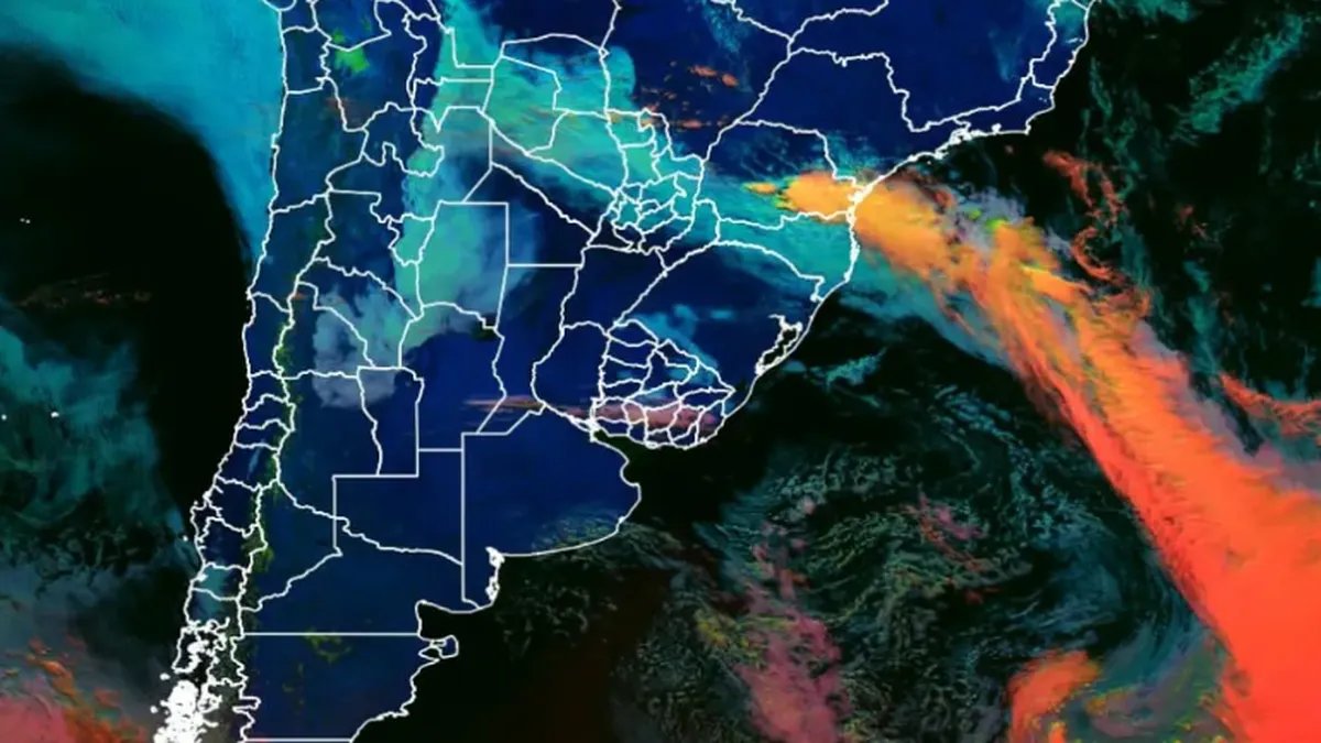
The image from the GOES-19 satellite, from NOAA and NASA, shows a large extratropical cyclone over the South Atlanticaway from the coast. According to Metsul, the phenomenon has two main effects: it moves a mass of cold air towards the south of the continent and generates a cold front that causes rain and storms over sectors of southern Brazil.
In Rio Grande do Sul, the cold air mass left a day with clear skies and temperatures close to 0 °C, while in other areas of the Southern Cone values below zero were recorded.
How will the weather continue in the region?
Metsul’s analysis indicates that a atmospheric blocking associated with a warm air mass over central Brazil will prevent the cold front from advancing northward. As a result, the system will remain virtually stationary and then begin to retreat southward.
This behavior will favor new rains between this Tuesday and the next few hours over the Brazilian states of Santa Catarina, Paraná and northern Rio Grande do Sulwhile the cold environment persists over much of southern South America.
For the moment, the report does not foresee that this front will generate phenomena of magnitude in Uruguay, although the country will continue under the influence of the cold air massresponsible for the frost and low temperatures recorded in recent days.
What Inumet predicts for this Tuesday in Uruguay
The scenario foreseen by Metsul coincides with the forecast of the Uruguayan Institute of Meteorology (Inumet)which anticipates for this Tuesday June 30 a day marked by intense coldwith widespread frosts, fogs and fog banks during the morning.
According to the organization, Minimum temperatures will drop to -2 °C in the east of the countrywhile the maximums will range between 13°C and 15°Cdepending on the region.
In Montevideo and the metropolitan area is expected minimum of 1 °C and maximum of 13 °Cwith clear and somewhat cloudy skies, periods of cloudiness, frost and fog during the morning. Towards the afternoon and evening the stable weather will continue, with an easterly wind between 10 and 20 km/h.
He east of the country will record the lowest temperatures of the day, with a minimum -2°C and a maximum of 13°C. In addition to frost, fog and fog banks are expected during the morning, conditions that could partially persist into the night.
In it westInumet predicts a minimum of 0 °C and a maximum of 14°Cwith morning frosts and clear to somewhat cloudy skies.
For him norththe organization foresees a minimum of 0 °C and a maximum of 15°C. There the morning will be somewhat cloudy and cloudy, with frost, fog and fog banks, while during the afternoon and night low temperatures and partial cloudiness will remain.