A sluggish tropical disturbance parked over the Marshall Islands is starting to organize, and the latest forecast models have nudged its potential path closer to Guam and the Marianas just as the island heads into the July 4th holiday weekend.
The National Weather Service Weather Forecast Office Guam said Tuesday that Invest 95W remains rated a medium chance for development by the Joint Typhoon Warning Center, meaning a tropical depression is likely to form, though not within the next 24 hours. The system has lingered in roughly the same spot southeast of Enewetak for days, struggling to pull itself together around a single low‑level circulation center.
Guam Homeland Security/Office of Civil Defense issued a public advisory Tuesday afternoon confirming there are no tropical cyclone watches or warnings in effect for Guam. The agency said it is coordinating with the weather service and urged residents to stay alert and keep up basic preparedness, even with no immediate danger on the books.
Landon Aydlett, warning coordination meteorologist with the weather service in Tiyan, told The Guam Daily Post Tuesday that the system has spent nearly a week barely moving in the Marshalls, which has made it difficult to pin down where it will eventually go.
“This 95W’s been spinning nearly stationary in the Marshall Islands region for several days now, since late last week,” Aydlett said.
For days, long-range guidance split between two outcomes: a track that stays well east of the Marianas in open ocean or one that clips the northern islands of the Commonwealth of the Northern Mariana Islands. Aydlett said that picture has started to change.
“Some of the trends we’ve seen over the last 24 hours is favoring more of a passage through the Mariana Islands, possibly shifting southward with potential forecast tracks,” he said. “So that’s a big concern to us here in Guam, especially as we move into the holiday weekend, that we could be dealing with an emerging significant threat to Guam and the lower CNMI islands.”
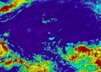
Satellite imagery shows the disturbance’s circulation consolidating south of Bikini Atoll, a position slightly west of where it sat earlier in the week, a shift Aydlett said could translate into a track farther south than previously expected. He cautioned that the system still has not pulled away from the Marshalls, and forecasters cannot lock in a track, timing, or strength until it does.
Asked whether 95W could grow into something more powerful than Tropical Depression Higos, which crossed the region earlier this month, Aydlett said the comparison offers little comfort.
“We’re not seeing those trends right now in the long-range models,” he said. “It’s still keeping a wide range of potential intensities, and some of those are quite alarming and worth the significant concern.”
He added that every storm behaves differently, and forecasters treat each one on its own terms rather than assuming a repeat of a weaker system. Current long-range projections range from a strong tropical storm to a major typhoon, he said, though it remains too early to know which scenario is more likely.
Despite the uncertainty out east, the outlook for the days immediately ahead stays favorable. Aydlett said Guam and the Marianas should see plenty of sunshine, scattered isolated showers, and moderate trade winds through the Fourth of July. Combined seas are forecast around four to five feet, with surf near five feet along east-facing reefs and beaches.
Conditions could begin to shift starting Saturday night into Sunday, he said, with any potential effects from 95W more likely Sunday into Monday, though he noted that timeline could move earlier or later depending on when the system finally clears the Marshall Islands.
“There’s still a number of days between us and eventual passage, and things can still shift, but it’s something that we have to watch closely, take very seriously, and maintain that awareness and preparedness,” Aydlett said.
He also cautioned against social media speculation already circulating about the storm’s potential path, saying no single scenario carries any certainty at this stage.
Residents can find the latest forecasts at weather.gov/gum.
For local updates and preparedness information from Guam Homeland Security/Office of Civil Defense, visit https://ghs.guam.gov or call 671-475-9600.