Storms are receding and giving way to extreme heat. Slovakia is preparing for the weekend, during which temperatures may reach the magical 40°C mark. The wave of abnormal heat, which is currently plaguing Western Europe, is inexorably approaching our territory.
23.06.2026 09:40 , updated: 11:51
After drier air penetrated to us from the north, we say goodbye to significant storms for some time. Over the mountains of central and eastern Slovakia, cumulus clouds with isolated showers may still form, but precipitation will be exceptional.
 Read more The heat in Europe chooses its victims: In France, siblings died in a hot car
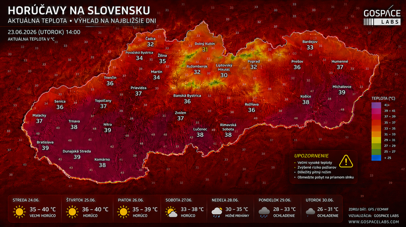
Temperatures remain high – up to 34 °C in the south, around 25 °C in the north. Starting tomorrow, however, the clouds will disappear and the mercury in the thermometer will start to rise sharply. This June will definitely be recorded as the fourth month in a row with significantly below-normal precipitation totals, with the exception of a few locations affected by local bursts.
The heat from France is heading to Central Europe
In France, they are currently battling extreme temperatures that routinely exceed 40°C, locally even up to 42°C. These masses of hot air are moving deeper into the interior of Europe every day, while they should probably peak in our territory on Monday with the passage of a cold front.
There is a real question on the table: Will we surpass the absolute historical record of 40.3 °C, which was measured in Hurbanov in July 2007? All meteorological factors play into this. High temperature at altitude: At the level of 850 hPa (approx. 1500 m above sea level), a temperature of around 23 to 24 °C is expected over our territory during the weekend. Add to that the extremely dry air: The dew point drops very low, only to around 10°C. In addition, the dried soil: the South-West of the territory currently suffers from the greatest deficit of moisture from the point of view of soil saturation, reminds Severe Weather Slovakia page.
SHMÚ also informed that the heat will peak at the end of this week and the beginning of next. Temperatures from 30 degrees in the north and 39 degrees in the southwest are expected. Even the border of 40 degrees can be attacked. At the same time, the probability of precipitation is low. Cooling appears on July 1-2. Meteorologist Nikoleta Hrušková informed about this at Tuesday’s press conference.
Dry and little precipitation
“The pressure height is stable over the interior of Europe not only in the ground layer, but also in the higher layers of the atmosphere. It becomes stationary and even blocking frontal systems that advance from the Atlantic Ocean towards the interior. These frontal systems do not actually reach the interior, or if they do, they quickly disintegrate under high pressure,” explained Hrušková.
In the coming days, he expects mainly dry weather and very little precipitation. Very warm to extremely warm weather will prevail. According to Hrušková, the night temperatures should mostly range from 21 to 22 degrees, in the mountain valleys it will be slightly colder.
He claims that the first precipitation could come to Slovakia on Monday (June 29) or Tuesday (June 30). However, they will be in the form of showers or storms, it will not be all-over rain. According to the expert, even intense storms should not occur now, they are possible at the beginning of next week.
“Several forecast models agree in this forecast, and this is also due to the fact that the pressure height is stationary and stable, so the deviations between the forecasts of some forecast models are minimal. Also, the deviation in the development of temperature, precipitation or cloudiness in the coming days is also minimal, so we must expect that the success of the forecast will be high,” concluded the meteorologist.

The combination of cloudless skies, extremely dry air and parched soil causes the ground layer to heat up much faster. The temperature difference between the height of 1500 meters and the ground can be up to 17 °C in such conditions, in extreme cases almost 20 °C.
Nature gets busy
It will already be extremely warm in the south-west on Saturday, but Sunday will bring the real peak, when highs in the lowlands could reach 40-41°C. The rest of the south can expect around 38°C and northern regions 33°C. In addition, the whole period will be without precipitation.
If we have to face such extremes, breaking the record would at least be a symbolic memento that would give the situation some meaning. However, the bitter reality remains – vegetation and animals take a particularly hard time in these conditions. It’s time to stop pretending that extremely high temperatures are a normal phenomenon for our extremities.