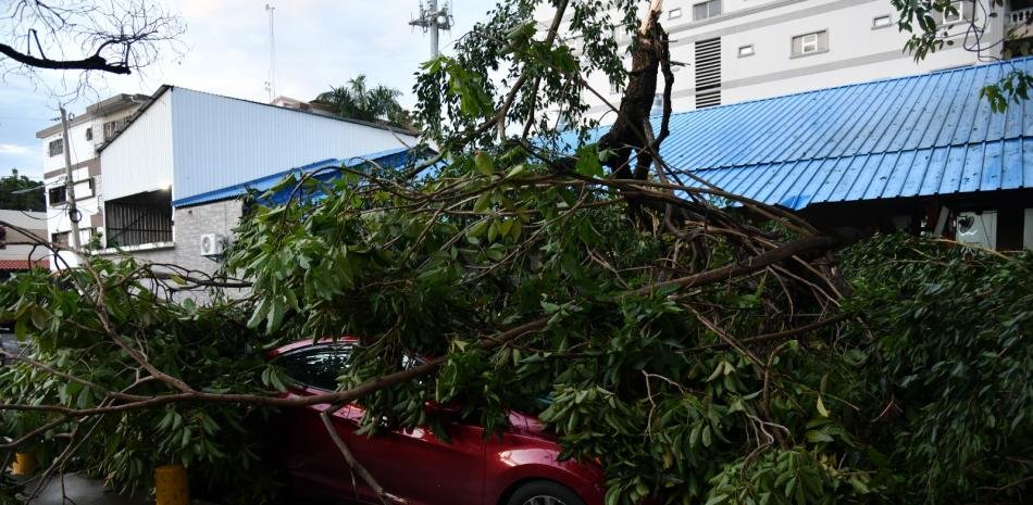
The winds that impacted the sector of Gascue and the University Zone on Monday afternoon, which uprooted trees and destroyed property, exceeded 100 kilometers per hour and were caused by a freak called microburst.
The director of the Dominican Institute of Meteorology (Indomet), Gloria Ceballosexplained that the microburst, also called wind blow, “is a very strong wind that suddenly descends from a vertically developing cloud towards the ground and expands with great intensity. It lasts a few minutes and causes severe damage in a small area, which is what happened in Gascue and the university area.”
He explained that it is a very focused event and “it looks like a tornado, but it does not rotate, it goes down in a straight line.”
For a microburst to occur, a series of conditions must occur, such as very cold temperatures at altitude and very warm temperatures on the surface, indicated the specialist. In technical language: “cold thermal anomaly”.
Temperatures of -12 degrees in the troposphere
When the event occurred, which caused panic among students of the Autonomous University of Santo Domingoas well as residents in the Gascue sector, workers and those who moved along the Malecón and those areas, the Greater Santo Domingo was in red alertdue to the threat of rain, winds and hailstorms.
Engineer Ceballos said that since the morning when “the radiosonde balloon was launched, that very cold temperature -12 degrees was observed in the middle troposphere and that is why the forecast explained that hailstorms and gusts of wind could occur.”
More about microbursts
One of the characteristics of a microburst is that they occur in a small perimeter, so these strong winds did not spread to other sectors of the Dominican capital.
According to the National Weather Service (National Water Service): “A microburst is a localized column of descending air (downdraft) within a thunderstormwith a diameter generally less than or equal to 4 kilometers (2.5 miles). “Microbursts can cause extensive surface damage and, in some cases, be life-threatening.”
The entity says that there are two main types of microbursts, one wet and the other dry. Wet microbursts are accompanied by significant precipitation and are common in the southeastern United States during the summer months.
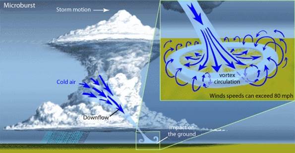
National Water Service Microburst Image
More about microbursts
The entity explains the causes of microbursts: “It all begins with the development of a thunderstorm and water droplets or hail that remain suspended in the ascending current. Sometimes this current is so strong that it keeps large amounts of droplets and hail on top of the storm“.
He also explains that “there are many factors that can cause evaporative cooling (air sinking) and therefore the weakening of the updraft. Once this occurs, the updraft is no longer able to support the core of rain or hail at the top of the storm. As a result, the core plummets to the ground. Upon impact with the ground, it disperses in all directions. The area where the microburst hits the ground first experiences the strongest winds and the most damage.” fragment of the text published by the National Water Service.