Tegucigalpa
The Secretary of State in the National Risk and Contingency Management Offices (Copeco) reported that for this Thursday, June 25, 2026, a change in the climatic conditions of the Honduran territory is expected due to the entry of a meteorological phenomenon in the afternoon.
During the morning, Hondurans will enjoy a mostly dry and hot environment in almost the entire country, ideal for outdoor activities. However, meteorological authorities warned that this panorama will change rapidly starting in the afternoon, when the entry of a tropical wave which will increase cloudiness and the probability of rain.
According to the official report, this meteorological phenomenon will produce Scattered weak rains and isolated showers. The areas where the impact of the tropical wave They will be the east, the northwest, the north and some areas of the central region of the national territory.
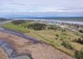
On the other hand, the report details the maritime parameters for vessels that operate on the Honduran coast. On the Caribbean coast there will be fairly calm waves, ranging between 1 and 3 feet high; meanwhile, in the Gulf of FonsecaIn the Pacific Ocean, waves will reach slightly higher heights, between 2 and 4 feet, with both ranges remaining within normal levels.
Finally, the report for the day, which takes place under the crescent moon phase, set the sunrise at 05:23 am and the sunset at 06:20 pm
The authorities of Copeco They urge the population of the regions that will be affected to take the necessary precautions against the afternoon showers and to stay informed through official alerts.