The eastern and central Pacific have become very active, with Hurricane Genevieve becoming the season’s first Category 5 while churning off the coast of Mexico, and Tropical Storm Fausto set to slide by the Hawaiian Islands this week. Meanwhile, Typhoon Dolphin, north of the Marshall Islands, is on track to become a super typhoon.
A busy Pacific hurricane season was expected due to the development and strengthening of El Niño. This warm plume of water creates ideal conditions for tropical storms and hurricanes to form and strengthen in the Pacific.
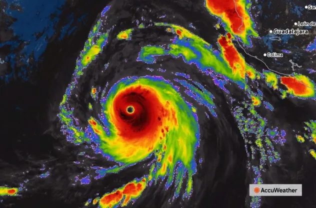
A tropical depression formed on the morning of July 24, well off the coast of Mexico, and became Tropical Storm Genevieve several hours later. A day later, on Saturday, Genevieve became a hurricane. Twenty-four hours later, on Sunday, Genevieve rapidly intensified and became a powerful Category 4 hurricane with maximum sustained winds of 155 mph. During the overnight hours on Sunday, Genevieve’s maximum winds reached 160 mph — a Category 5 hurricane.
This image, captured early Monday morning on July 27, 2026, shows Category 5 Hurricane Genevieve with 160-mph maximum sustained winds. (AccuWeather Enhanced RealVue™ Satellite)
“While eastern Pacific Major Hurricane Genevieve poses no direct threat to land, it has become the most powerful hurricane in the waters surrounding North and Central America this year and the first Category 5 hurricane since Kristy in 2024,” AccuWeather’s Lead Hurricane Expert Alex DaSilva said.
As of midday Tuesday, Genevieve was a 125-mph Category 3 hurricane. The hurricane will track northwest through the end of the week.
Genevieve should slowly lose wind intensity from mid- to late week and become a tropical storm by the weekend. Massive swells generated by the powerful storm will extend outward from the center and reach the west coast of Mexico and California as sets of large waves that could pose dangers to small craft and swimmers.
This wide view image of the tropical Pacific was captured in the early morning on Tuesday, July 27, 2026, and shows rapidly strengthening Typhoon Dolphin (left), Tropical Storm Fausto (center) and Major Hurricane Genevieve (right). Hawaii appears in the center. (AccuWeather Enhanced RealVue™ Satellite)
Meanwhile, Fausto is forecast to pass north of Hawaii by midweek.
“Fausto, which became a hurricane last week while just off the coast of Mexico, has moved along a general west to west-northwest path for days,” DaSilva said. “Just enough of a northward drift has occurred to take the slowly unwinding tropical cyclone and most of its impacts north of the Hawaiian Islands this week.”
As Fausto loses intensity over the rest of the week, transitions to a tropical rainstorm and passes well to the north, a plume of moisture may extend into the storm from the south, and the showers and gusty thunderstorms associated with it may tend to spread out.
“That’s about the only way parts of Hawaii may get any rain from Fausto,” DaSilva said. “But any problems from flash flooding would be extremely isolated.”
Fausto still has enough wind intensity to send swells outward from the center, which will reach the north- and northeast-facing shores of the islands in the form of large breakers, rough surf and rip currents.
More than 2,000 miles southwest of Hawaii, just north of the Marshall Islands, Dolphin formed in the middle of the Pacific. Typhoon Dolphin has rapidly intensified since Monday and now has maximum sustained winds of 145 mph. It is forecast to become a super typhoon with maximum sustained winds of 170 mph in the next couple of days.
Both Dolphin and Genevieve are very dangerous storms for cross-Pacific shipping.
Numerous tropical storms and hurricanes are forecast for the eastern and central Pacific basins in 2026, due to the impacts of El Niño.
Want next-level safety, ad-free? Unlock advanced, hyperlocal severe weather alerts when you subscribe to Premium+ on the AccuWeather app. AccuWeather Alerts™ are prompted by our expert meteorologists who monitor and analyze dangerous weather risks 24/7 to keep you and your family safer.