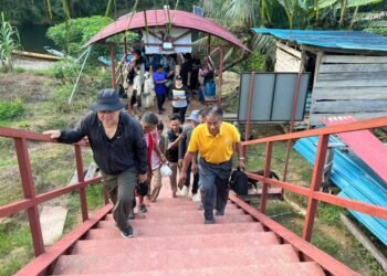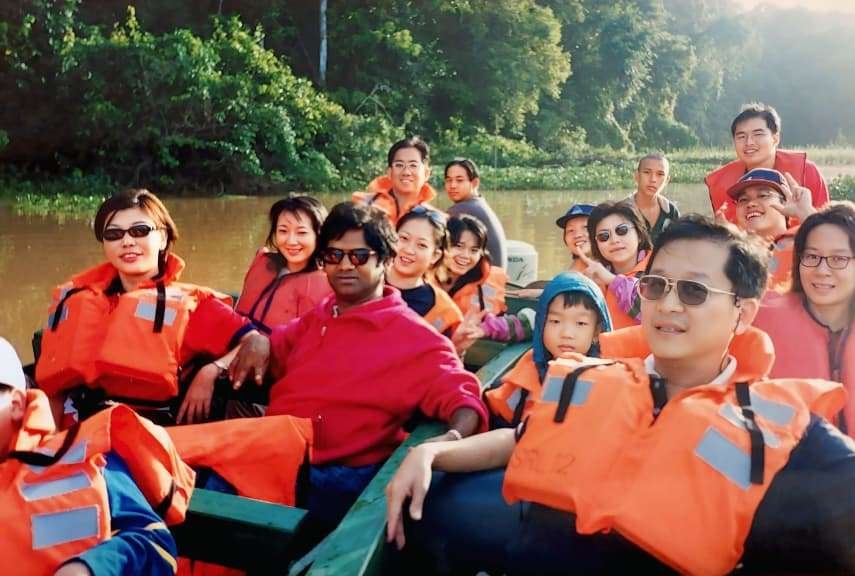

The columnist and a tour group on a short ride along the Kinabatangan, a river that has shaped Sabah for generations.
![]() WHILE many Sabahans are familiar with the rivers near their own communities, far fewer are acquainted with the Kinabatangan, Sabah’s longest and most storied river. I still remember my journey to Sukau at the turn of the century in 2000, when I joined a group tour and found myself gliding along a tranquil stretch of the Kinabatangan River.
WHILE many Sabahans are familiar with the rivers near their own communities, far fewer are acquainted with the Kinabatangan, Sabah’s longest and most storied river. I still remember my journey to Sukau at the turn of the century in 2000, when I joined a group tour and found myself gliding along a tranquil stretch of the Kinabatangan River.
As our boat cut through its murky waters, I was struck not only by the richness of life around me; crocodiles resting along the banks and proboscis monkeys moving gracefully through the trees but also by the quiet realisation that this river was more than a scenic attraction. It was a lifeline sustaining both wildlife and human communities, even as the signs of logging and environmental strain were already visible. That experience left me with a deep appreciation of the Kinabatangan, not just as a river but as a powerful force that has shaped history, culture and livelihoods in Sabah for generations.
More than a geographical feature, the Kinabatangan River is a living artery that has defined the identity and development of eastern Sabah. Stretching about 560 kilometres from the mountainous interior to the Sulu Sea, it is among the ecologically significant river systems in Southeast Asia. For centuries, it has functioned as a corridor of movement, a cradle of culture and a driver of economic transformation. Even today, it remains central to discussions about sustainability, environmental protection and the balance between development and conservation.
Understanding the Kinabatangan begins with its name, which reflects both linguistic heritage and cultural significance. Among several interpretations, the most convincing explanation lies in local language traditions. The prefix “kina-” appears frequently in place names across Sabah, often indicating a place or association while “batang,” found in Malay and related Austronesian languages, refers to a river or main stem. Combined, the name most plausibly conveys the meaning of a great or principal river system. This interpretation aligns closely with its physical dominance and long-standing role as the main artery through which people, goods and ideas moved across eastern Sabah. Although some theories suggest links to early Chinese trade, supported by the discovery of ceramics, the linguistic structure itself strongly supports an indigenous origin rooted in the way local communities understood their landscape.
Geological history stretches far deeper than human settlement. Formed during the Miocene epoch millions of years ago, the basin developed into a rich mosaic of limestone outcrops, oxbow lakes, wetlands and dense lowland rainforest. These varied ecosystems support a remarkable concentration of biodiversity, making the region one of the important ecological areas in Southeast Asia. Long before roads reached the interior, the river served as a natural highway. Early inhabitants travelled by canoe, using it as their primary route for movement, trade and communication. Settlements such as Sukau, Abai and Bilit emerged along its banks, shaped by seasonal rhythms, fertile soils and access to water. In that sense, the Kinabatangan did more than connect places; it shaped patterns of settlement and human interaction.
Evidence of early external connections can be found through archaeological discoveries. Chinese ceramics dating to the Song Dynasty (960–1279) and the Ming Dynasty (1368–1644) have been uncovered along the lower reaches, indicating that the river was part of wider regional trade networks. These artefacts, clearly not locally produced, point to long-distance exchange rather than migration. Foreign traders likely operated near coastal areas while local intermediaries transported goods along the river. Forest products such as camphor, resins, rattan and edible bird’s nests moved downstream while ceramics, textiles and metal goods were brought inland. In this way, the river functioned as a vital connector, integrating remote communities into broader regional economies.
Life along the river gave rise to distinctive cultural traditions, particularly among the Orang Sungai communities. Their relationship with the river is deeply embedded in identity, shaping not only livelihoods but also values and worldview. Fishing has long provided sustenance and income while seasonal floods deposit nutrient-rich silt that supports small-scale agriculture. These natural cycles are understood as predictable patterns that guide daily life rather than disruptions. Homes built on stilts reflect practical adaptation to flooding, demonstrating a deep understanding of environmental conditions developed over generations.
Cultural expressions further reflect this close connection. Folklore, oral histories and everyday language often reference animals such as crocodiles and monkeys, not as distant symbols but as part of a shared environment. Such narratives reinforce a worldview rooted in coexistence rather than domination. The river stands as more than a resource; it is a living presence that commands respect.
Over time, traditions have evolved alongside changing economic realities. Many residents now participate in eco-tourism, guiding visitors, operating boats and sharing local knowledge. This transition has allowed communities to preserve cultural identity while adapting to new opportunities. Instead of abandoning tradition, they have reinterpreted it, transforming knowledge of the river into a valuable economic asset.
Sukau offers a clear and compelling illustration of the way the river shapes community life. The village does more than sit beside the Kinabatangan; it exists because of it. Daily routines are influenced by water levels, weather and seasonal change. Boats remain essential for mobility, linking homes, workplaces and neighbouring settlements. Early mornings often begin with the sound of engines as guides prepare for wildlife cruises and fishermen head out. Evenings bring a slower rhythm as the river reflects fading light and the surrounding forest comes alive with sound.
Settlement patterns reflect this dependence. Houses stand on stilts, connected by wooden walkways that allow movement even during periods of flooding. The village stretches along the riverbank, ensuring direct access to water. This layout underscores the central role of the river as both pathway and lifeline, shaping not only physical space but also social interaction.
Livelihoods in Sukau illustrate a broader transformation. Fishing and subsistence farming once dominated economic activity, with the river providing both food and modest income. Gradually, eco-tourism has reshaped the local economy. Visitors are drawn by the region’s extraordinary biodiversity, and the river has become the main stage for wildlife observation. Boat operators, guides, lodge staff and small business owners all depend on its continued health. Income now flows not only from extraction but from conservation, reflecting a shift in the way natural resources are valued.
Social relationships are influenced by this shared dependence. Living in close proximity and facing common challenges foster cooperation and mutual support. Floods, for instance, require collective response, reinforcing community bonds. Identity is closely tied to place, with residents seeing themselves as part of a riverine ecosystem rather than separate from it. Knowledge accumulated over generations plays a crucial role. Subtle changes in water colour, animal behaviour or weather patterns are interpreted with remarkable accuracy, guiding both daily life and tourism activities.
Challenges, however, are increasingly evident. Environmental degradation upstream has affected water quality and fish stocks, altering livelihoods that have existed for generations. Flooding can be more severe, influenced by deforestation and changing climate patterns. Human-wildlife conflict has intensified as natural habitats shrink, bringing animals into closer contact with human activity. Despite these pressures, communities continue to adapt, drawing on resilience shaped by long experience and a deep connection to the river.
Economic history reflects both growth and consequence. During the mid-twentieth century, the river became a key channel for the timber industry. Logs were transported downstream in large quantities, contributing to Sabah’s economic development. Environmental costs were significant, including soil erosion and increased sedimentation, which continue to affect water quality today.
As timber resources declined, oil palm cultivation expanded across the floodplain. While economically beneficial, this shift resulted in extensive habitat loss and fragmentation. Wildlife populations became confined to smaller forest corridors, increasing ecological pressure and intensifying conflict.
In response, eco-tourism has emerged as a more sustainable model. The Kinabatangan is now recognised internationally as a prime destination for wildlife viewing, and Sukau has become a central hub for river-based tourism. This transition demonstrates that economic activity can align with conservation although maintaining that balance requires careful planning and long-term commitment.
Social and political developments have followed a similar trajectory. Growing awareness of environmental degradation has led to conservation initiatives, including the establishment of protected areas such as the Kinabatangan Wildlife Sanctuary. Recognition as a biosphere reserve further underscores its global importance and highlights the need for sustainable management.
Pressures on the river persist. Agricultural expansion, pollution and climate change continue to affect ecosystems and communities. These pressures often remain subtle at first, yet they gradually weaken the river’s ecological balance and the livelihoods that depend on it. Added to this is the long-term impact of the timber industry, which cleared vast stretches of forest along the basin. Logging not only reduced natural habitats but also increased soil erosion, sending sediment into the river and degrading water quality. The combined effects have reduced the river’s resilience, making recovery slower and more complex.
Looking ahead, the future of the Kinabatangan depends on achieving balance between development and sustainability. Reforestation and wildlife corridor projects aim to restore ecological connectivity while sustainable agricultural practices seek to reduce environmental impact. Involvement of local communities remains essential, ensuring that conservation efforts are grounded in lived experience and practical realities.
Global recognition brings opportunities for funding, research and collaboration but also raises expectations for effective governance. Long-term success will depend on sustained commitment from government, industry and communities working together toward a shared vision.
Reflection on that journey to Sukau reveals more than a personal memory. It represents a moment within a broader narrative, one in which a river continues to shape lives, landscapes and futures. The murky waters I saw served as more than signs of degradation; they were reminders of the complex relationship between human activity and the natural world.
The Kinabatangan remains, in every sense, Sabah’s river of life. It has shaped landscapes, nurtured cultures, driven economies and connected communities across generations. Its future will depend on the choices made today. With careful stewardship, it can continue to flow as both a natural wonder and a lasting legacy for Sabah and beyond.
Dr Richard A. Gontusan is a Human Resource Skills Training and Investment Consultant. He writes on academic, economic, political and social issues. His views expressed in this article are not necessarily the views of The Borneo Post.