On Wednesday, a small cyclone named Yuna reached us from the south, southwest, its wavy atmospheric front is moving across Lithuania, so during the day it is already raining in some places, and thunderstorms are recorded in some places.
It is already cooler in the western part of Lithuania, but the south-eastern and southern regions will still heat up a lot, so there will be thunderstorms and more hail, stronger gusts of wind.
It is predicted that the highest probability of a summer storm is in the southeastern part of the country (Druskininkų municipality, Varėnas district, Šalčininkų district and the southern part of Vilnius district).
In the meantime, the company “Grinda”, which maintains the streets of Vilnius city, warns the citizens about the possible impact of a strong storm. The company reports on its Facebook account that although it is more likely that the storm will only reach the Vilnius region, it urges the residents of the city to prepare as well.
Meteorologists predict that from around 5 p.m. the air temperature can drop sharply to 20 °C, and wind gusts can reach up to 25 m/s. It is also announced that heavy rains and hail are possible.
“We have already mobilized additional forces to respond promptly to flooded streets, fallen trees or other emergency situations, if necessary,” the company said in a statement.
Vilnius was hit by a downpour: images were captured on the streets of the capital
Meteo.lt announces that, based on 12 p.m. 30 minutes according to data, rain clouds are moving in Western Lithuania, storm clouds are moving in the southern regions, and in some places they are accompanied by thunderstorms. The main band of storms is moving northeast.
In the coming hours, the rain clouds will continue to move in the northeast direction, short rains, thunderstorms and hail are expected in many places.
Based on the 2:10 p.m. according to data, storm clouds are moving across Southern Lithuania, accompanied by thunderstorms and wind intensifications of up to 15-20 m/s in many places. The main band of storms is moving northeast. In the coming hours, the rain clouds will continue to move in the northeast direction, short rains, thunderstorms, hail in some places are expected in many places, wind gusts from the eastern directions will reach 15-20 m/s
Based on the 3:55 p.m. according to data, storm clouds are moving across Lithuania, accompanied by thunderstorms and wind intensifications of up to 15-20 m/s in many places. The main band of storms is moving towards the northeast, meteo.lt announced.
Around 4 p.m. 20 minutes the first reports from Vilnius appeared. Around 4 p.m. 30 minutes the black clouds had moved away – the sky darkened and in the center, lightning flashed and thunder was heard. True, as quickly as the restless element receded, it calmed down quickly enough.
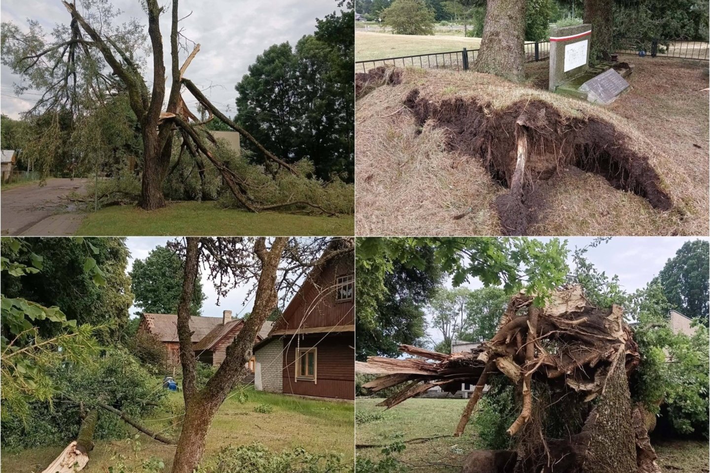
At around 8 p.m., the mayor of Varėna district municipality, Algis Kašėta, announced that the severe storm did not overtake the villages and settlements of Valkininkai ward in Varėna district.
The mayor also shared images from settlements where the effects of the natural disaster are clearly visible.
The Facebook page “Weather and climate in Lithuania” also reported that about a third of July rain fell in Alytus today. norms.
“It rained. Today in Alytus, about a third of the July norm fell (the rain repeatedly fell in a rather narrow stretch). Roughly, all surfaces received three large buckets of water per 1 m². A test for the streets and drivers. Don’t lose your numbers when you drive through such temporary lakes,” wrote “Weather and Climate in Lithuania”