Thursday, May 7, 2026
    The GeoStrategic Consensus
    No Result
    View All Result
    • Login
    • HOME
    • AMERICAS
      • Argentina
      • Brazil
      • Canada
      • Chile
      • Colombia
      • Costa Rica
      • Cuba
      • Dominican Republic
      • Ecuador
      • El Salvador
      • Greenland
      • Guatemala
      • Honduras
      • Mexico
      • Nicaragua
      • Panama
      • Paraguay
      • Peru
      • United States
      • Uruguay
      • Venezuela
    • ASIA-PACIFIC
      • Australia
      • Brunei Darussalam
      • Cambodia
      • China
      • Federated States of Micronesia
      • Fiji
      • Indonesia
      • Japan
      • Kiribati
      • Laos
      • Malaysia
      • Marshall Islands
      • Mongolia
      • Myanmar
      • Nauru
      • New Zealand
      • North Korea
      • Palau
      • Papua New Guinea
      • Philippines
      • Samoa
      • Singapore
      • Solomon Islands
      • South Korea
      • Taiwan
      • Thailand
      • Timor-Leste
      • Tonga
      • Tuvalu
      • Vanuatu
      • Vietnam
    • CARICOM
      • CARICOM – Non-English
        • Haiti
        • Suriname
      • CARICOM Associates
        • Anguilla
        • Bermuda
        • British-Virgin-Islands
        • Cayman-Islands
        • Curacao
        • Turks-and-Caicos
      • CARICOM English
        • Antigua and Barbuda
        • Barbados
        • Belize
        • Dominica
        • Grenada
        • Guyana
        • Jamaica
        • Montserrat
        • Saint Kitts and Nevis
        • Saint Lucia
        • Saint Vincent and the Grenadines
        • The Bahamas
        • Trinidad and Tobago
    • EURASIA
      • Armenia
      • Azerbaijan
      • Balarus
      • Georgia
      • Kazakhstan
      • Kyrgyzstan
      • Moldova
      • Russia
      • Tajikistan
      • Turkmenistan
      • Ukraine
      • Uzbekistan
    • EUROPE
      • Albania
      • Andorra
      • Austria
      • Bosnia and Herzegovina
      • Bulgaria
      • Croatia
      • Cyprus
      • Czech Republic
      • Denmark
      • Estonia
      • Finland
      • France
      • Germany
      • Greece
      • Holy See
      • Hungary
      • Iceland
      • Ireland
      • Italy
      • Kosovo
      • Latvia
      • Liechtenstein
      • Lithuania
      • Luxembourg
      • Malta
      • Monaco
      • Montenegro
      • Netherlands
      • North Macedonia
      • Norway
      • Poland
      • Portugal
      • Romania
      • San Marino
      • Serbia
      • Slovakia
      • Slovenia
      • Spain
      • Sweden
      • Switzerland
      • United Kingdom
    • MIDDLE EAST AND NORTH AFRICA
      • Algeria
      • Bahrain
      • Egypt
      • Iran
      • Iraq
      • Israel
      • Jordan
      • Kuwait
      • Lebanon
      • Lybia
      • Morocco
      • Oman
      • Palestinian Territories
      • Qatar
      • Saudi Arabia
      • Syria
      • Tunisia
      • Turkey
      • United Arab Emirates
      • Western Sahara
      • Yemen
    • SOUTH ASIA
      • Afghanistan
      • Bangladesh
      • Bhutan
      • India
      • Maldives
      • Nepal
      • Pakistan
      • Sri Lanka
    • SUB-SAHARAN AFRICA
      • Angola
      • Benin
      • Botswana
      • Burkina Faso
      • Burundi
      • Cabo Verde
      • Cameroon
      • Central African Republic
      • Chad
      • Comoros
      • Cote d’Ivoire
      • Democratic Republic of the Congo
      • Djibouti
      • Equatorial Guinea
      • Eritrea
      • Eswatini
      • Ethiopia
      • Gabon
      • Gambia
      • Ghana
      • Guinea
      • Guinea Bissau
      • Kenya
      • Lesotho
      • Liberia
      • Madagascar
      • Malawi
      • Mali
      • Mauritania
      • Mauritius
      • Mozambique
      • Namibia
      • Niger
      • Nigeria
      • Republic of the Congo
      • Rwanda
      • Sao Tome and Principe
      • Senegal
      • Seychelles
      • Sierra Leone
      • Somalia
      • South Africa
      • South Sudan
      • Sudan
      • Tanzania
      • Togo
      • Uganda
      • Zambia
      • Zimbabwe
    No Result
    View All Result
    Agentially
    No Result
    View All Result
    Home ASIA-PACIFIC Marshall Islands

    As satellite imagery evolves, its role in operations comes into view

    The Analyst by The Analyst
    May 7, 2026
    in Marshall Islands
    As satellite imagery evolves, its role in operations comes into view


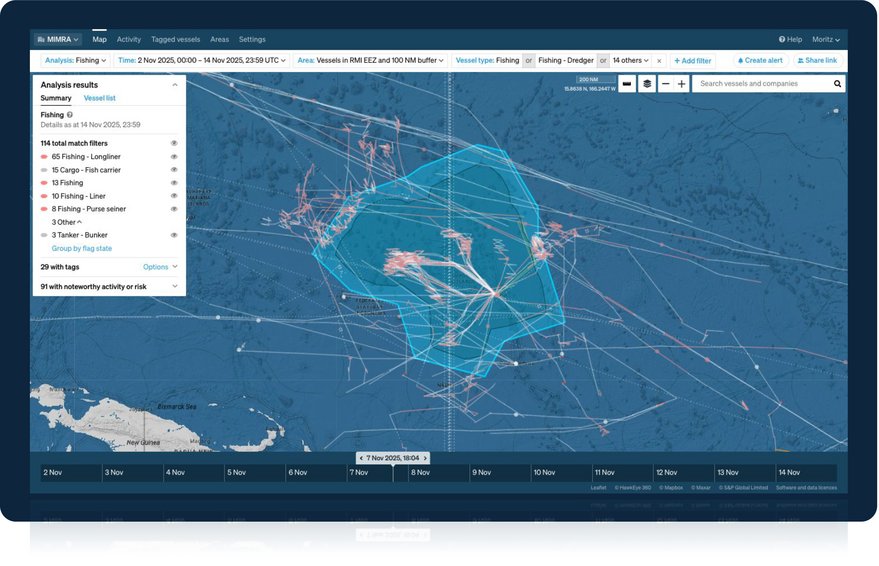
    DENVER – In the last year, leaders from the Republic of the Marshall Islands, a 181-square kilometer landmass surrounded by two million square kilometers of water, wanted to reduce the time it takes to detect of vessels suspected of illegal fishing.

    READ ALSO

    10,800 tourists arrive in Kusadasi aboard four cruise ships

    Pacific.scoop.co.nz » Marshall Islands Welcomes First Of 2 New US-Made Planes

    During a 12-day campaign by the Marshall Islands Marine Resources Authority, satellite radar and optical imagery were combined with automated identification system (AIS) and vessel-monitoring data in an analytic engine from Starboard Maritime Intelligence.

    The New Zealand-based firm focuses on AI-driven, real-time tracking and risk analysis for global maritime activity.

    Starboard’s system looked specifically for vessels “showing long deployments, transshipments or [identification] conflicts, and pushed actionable cues directly to aircraft in flight,” Robert Cardillo, chairman of the U.S. Geospatial Intelligence Foundation (USGIF) board of directors, said May 4 at the 2026 GEOINT Symposium.

    The campaign worked. The group reduced the detection time from days to hours.

    Each year at the GEOINT Symposium, leaders tout the work of the satellite imagery and analytics industry as well as the success that has come from their technological advances. But because much of that tradecraft overlaps with the work of intelligence agencies, where secrecy is paramount, details can be scant or hard to prove. This year, SpaceNews worked with USGIF to share the stories on how these technologies were applied in operations.

    In the case of the Marshall Islands, the campaign, called Operation Nightwatch, detected 43 vessels, confirmed six high-priority targets and then verified targets in five hours.

    Below are several other vignettes that show real-life examples of how the new technologies are being used, and which companies and applications are pushing the underlying technology forward.

    Amphibious activity

    At the GEOINT Symposium, in another example, USGIF leaders lauded BlackSky for revealing what appeared to be coordinated amphibious activity on China’s coast.

    There, Blacksky combined high-frequency satellite imagery with artificial intelligence to highlight activity that “suggested a military rehearsal, rather than isolated training,” said USGIF CEO Ronda Schrenk.

    By monitoring about 100 vessels, BlackSky detected activity near military barges at a shipyard, amphibious vessels repeatedly moving from water to land to barges and civilian ferries designed to move cars, trucks and buses operating nearby.

    “Individually, these activities can appear deceptively routine and isolated,” Schrenk said. “But dawn-to-dusk imagery and AI-driven analytics turn dispersed activity into a coherent pattern, reducing uncertainty and informing decisionmakers.

    A small Oregon brushfire was among the first images captured by Firesat, the first satellite Muon Space built and launched in 2025 for the nonprofit Earth Fire Alliance. Credit: Earthfire Alliance

    Spotting fires

    A small Oregon brushfire was among the first images captured by Firesat, the first satellite Muon Space built and launched in 2025 for the nonprofit Earth Fire Alliance.

    The satellite’s mid-wave infrared sensor pinpointed a roadside fire that covered less than one-fifth of a hectare and wasn’t picked up by traditional sensors, Cardillo said.

    “The detection demonstrates advanced sensitivity, and a breakthrough capability to find fires at their earliest, most manageable stage,” he added.

    Eye on nuclear sites

    When international monitoring of the Iranian nuclear program under the Joint Comprehensive Plan of Action ended in October, Iceye provided daily observation of Iranian sites damaged in 2025 U.S. and Israeli strikes.

    Iceye’s Ground Track Repeat Synthetic Aperture Radar constellation collected daily imagery of nine sites at the same time, from the same angle. The processed data showed extensive damage and little sign of reconstruction, a key metric to the military’s objectives.

    “Iran’s damaged nuclear sites weren’t being rebuilt – at least not where anyone could see them,” Cardillo said.

    To keep tabs on activity around Antelope Reef in the South China Sea, Vantor integrated Google foundation models into its Sentry persistent monitoring application. Credit: Vantor

    Watching the South China Sea

    To keep tabs on activity around Antelope Reef in the South China Sea, a strategically important area of the South China Sea, Vantor integrated Google foundation models into its Sentry persistent monitoring application.

    This allowed for more comprehensive analysis and monitoring in the China-controlled region, where the country built an artificial island in waters over which Vietnam and Taiwan also have competing claims for ownership.

    “The app allows human analysts to interact with the data and leverage agentic capabilities to develop intelligence reports about ongoing activity — and even deliver recommendations or predictions on what is likely to happen in the coming days or weeks,” Schrenk said.

    “These capabilities unlock continuous pattern-of-life analysis at Antelope Reef and across the larger contested area.”

    Maritime monitoring

    Safran’s HyperReveal, an artificial intelligence and machine learning system built for object detection, helped an unidentified Defense Department customer detect, classify and identify maritime vessels and transmit information directly from space to field terminals.

    A Safran mobile antenna handled the downlinks and prepared raw data for processing before passing data to HyperReveal. The system classified nearly 4,000 vessels across 1,600 square kilometers in less than eight minutes.

    HyperReveal was trained by imagery analysts, “a human-in-the-loop approach that drives higher accuracy than a fully automated system ever could,” Cardillo said. “That’s not just faster analysis, it’s a step-change in operational speed, accuracy and autonomy.”

    High-value hubs

    Jane’s developed a process to identify and geolocate ground-based radar, air-defense and electronic-warfare systems. The process combines radio frequency interference data with satellite imagery and open-source intelligence.

    By pairing the datasets with other sources of intelligence, “Janes identified layered force-protection architectures surrounding high-value Russian capabilities including command-and-control nodes, logistics hubs and other critical warfighting functions,” Schrenk said.

    Jamming artifacts

    Similarly, Whitespace, a company that develops AI operating systems for government customers, simplified discovery of likely sites of GPS jamming by automating detection of artifacts in geospatial imagery.

    Through automated analytics to looks for artifacts, which look like points jumping around on a map, Whitespace can show the timing and location of past interference and reveal ongoing jamming in streaming data, Schrenk said. “This rapid, automated capability can aid analysts who want to spot degraded data impacting their analysis, inform commanders of dangers to navigation or enable the targeting of jamming equipment.

    The U.S. Army employed an Urban Sky high-altitude Microballoon with an electro-optical sensor to detect and classify vessels, vehicles and aircraft across a broad area. Credit: Urban Sky

    Vehicle detection

    One vignette USGIF shared involved a high-altitude ballon rather than satellites. The U.S. Army employed a high-altitude Microballoon with an electro-optical sensor from Urban Sky a Denver-based startup. An AI-and-ML model then detected and classified vessels, vehicles and aircraft across a broad area.

    “Detections reach the operator’s mission system in under three minutes via Starlink,” Schrenk said. “No satellite tasking. No [intelligence, surveillance, reconnaissance] queue.”

    “Urban Sky is now delivering operational systems to the Army’s 1st Multi-Domain Task Force for field experimentation,” Schrenk said.

    Target tracking

    Auria Space developed the Auria Cerux platform to apply agentic AI to satellite constellation planning.

    Since it’s difficult to re-task constellations quickly enough to keep tabs on moving targets, Cerux synchronizes handovers between satellites and coordinates sensor types, Schrenk said. “The result is a reactive, self-optimized network, a system that tips and cues itself to capture better ‘looks,’ from better angles and sustain continuous custody of critical moving targets.”

    Related


    Source link

    Related Posts

    10,800 tourists arrive in Kusadasi aboard four cruise ships
    Marshall Islands

    10,800 tourists arrive in Kusadasi aboard four cruise ships

    May 7, 2026
    Pacific.scoop.co.nz » Marshall Islands Welcomes First Of 2 New US-Made Planes
    Marshall Islands

    Pacific.scoop.co.nz » Marshall Islands Welcomes First Of 2 New US-Made Planes

    May 7, 2026
    Weak Mag. 2.4 Earthquake – North Pacific Ocean, 71 km South of Marshall Island, British Columbia, Canada, on Tuesday, May 5, 2026, at 08:26 pm (GMT -9)
    Marshall Islands

    Weak Mag. 2.4 Earthquake – North Pacific Ocean, 71 km South of Marshall Island, British Columbia, Canada, on Tuesday, May 5, 2026, at 08:26 pm (GMT -9)

    May 6, 2026
    Marshall Islands

    Solomon Islands Joins Cook Islands, American Samoa, Federated States of Micronesia …

    May 6, 2026
    When the price of fuel becomes the price of childhood: Pacific families in a crisis
    Marshall Islands

    When the price of fuel becomes the price of childhood: Pacific families in a crisis

    May 6, 2026
    Marshall Islands

    World Bank Launches Six-Year Pacific Partnership to Boost Jobs, Climate Resilience, and Economic Stability

    May 6, 2026
    Next Post
    Cultural links leave lasting memories

    Cultural links leave lasting memories

    POPULAR NEWS

    Justin Bieber fans flood Coachella festival for headlining show – Entertainment

    Justin Bieber fans flood Coachella festival for headlining show – Entertainment

    April 20, 2026

    Over 600 flee homes as Army, NPA clash in Negros Occidental

    April 21, 2026

    Ex-DPWH exec recalls P800-M ‘delivery’ to Zaldy Co 

    April 20, 2026

    Former PM Paluckas suspends party membership, to waive immunity over criminal probe

    April 24, 2026
    Pres. Ali challenges CARICOM to transform into health research powerhouse

    Pres. Ali challenges CARICOM to transform into health research powerhouse

    April 23, 2026

    EDITOR'S PICK

    Protests: Pot-banging in broad daylight during protests in Havana

    Protests: Pot-banging in broad daylight during protests in Havana

    April 9, 2026
    What do French people mean by the ‘second degree’?

    What do French people mean by the ‘second degree’?

    April 29, 2026
    Resource curse has taken root in Guyana – Ram warns

    Resource curse has taken root in Guyana – Ram warns

    May 5, 2026
    Al-Zaidi for Al-Zaman: The plain plain distinguishes water-based dyes

    Al-Zaidi for Al-Zaman: The plain plain distinguishes water-based dyes

    May 3, 2026

    Recent Posts

    • SNA who fell and broke wrist was ‘author of her own misfortune’ and must pay school’s €30,000 legal costs
    • Trampoline injuries: how to protect children from serious consequences
    • The Euroleague quarter-final series is not dead: Žalgiris, after 38 minutes behind, finally broke Fenerbahce
    • 72 women spoke about what was kept silent for a long time: an extraordinary event brought together a group of bright personalities | Names

      © 2026 Agentially - Navigating shifting sovereignties and global risk .

      Welcome Back!

      Login to your account below

      Forgotten Password?

      Retrieve your password

      Please enter your username or email address to reset your password.

      Log In
      No Result
      View All Result

        © 2026 Agentially - Navigating shifting sovereignties and global risk .

        This website uses cookies. By continuing to use this website you are giving consent to cookies being used. Visit our Privacy and Cookie Policy.