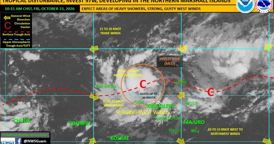
A tropical disturbance northwest of Kwajalein, Invest 97W is slowly developing over the northern Marshall Islands and there is a possibility it could make its way towards the Mariana Islands, the National Weather Service said.
NWS issued a supplemental weather outlook on Friday with information about the tropical disturbance.
As of Friday, Invest 97W was centered near 11.8N 165.9E, or 261 nautical miles northwest of Kwajalein, it is in a favorable environment for gradual development in the coming days.
Forecast models favor a slow track to the northeast with steady consolidation of the disturbance during the next 1-2 days, NWS said.
97W is rated medium for development by the Joint Typhoon Warning Center. This means that development into a tropical depression is likely, but beyond 24 hours from now.
A developing tropical disturbance, even if it is not a tropical depression, a tropical storm, or even a typhoon, can result in hazardous conditions and potentially significant impacts.
97W is generating strong west winds across the Marshall Islands, particularly along the Ralik chain and northward toward 97W.
Long range numerical models continue to push a variety of scenarios, some of which do bring 97W, in some form closer to the Marianas.
These forecast solutions are still in the long-range. At this time, 97W does not pose a direct threat to Guam or the Commonwealth of the Northern Mariana Islands.
“However, stay tuned to regional forecasts and discussions as this will be an evolving regional weather set up. If 97W does evolve into a threat for the Marianas, we’ll be communicating this threat,” NWS said.