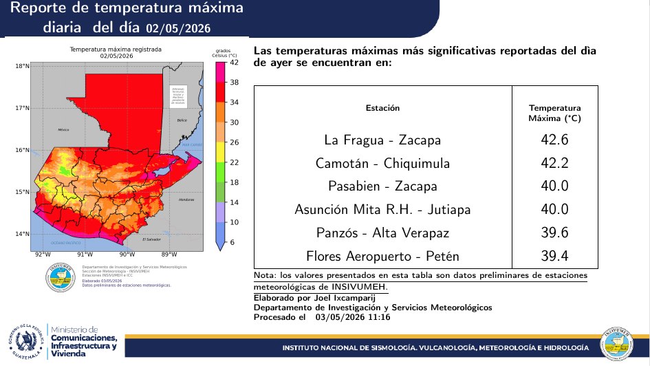
While the Guatemala City exceeded 32 °C on several days in May, in The Forge, Zacapathe thermometer reached 42.6°C. The National Institute of Seismology, Volcanology, Meteorology and Hydrology (Insivumeh) confirmed that these conditions were part of a heat wave which mainly affected the east and north of the country.
The director of the institution, Edwin Rojas, explained that the persistence of extreme temperatures allowed confirming the occurrence of this phenomenon, whose greatest impacts were concentrated in the east of the country, as well as in northern sectors for several weeks.
“Yes, indeed, our country has registered a heat wave unique to the moment, where temperatures of up to 42.6 °C could be observed, mainly in the region of La Fragua, Zacapa.also in Camotán, Pasabien and Panzós, Alta Verapaz“, he indicated on June 1 regarding the conditions that marked the weather at the end of April and during May.
According to Rojas, the records obtained will allow comparisons with historical data between 1991 and 2000, which confirms the magnitude of the temperatures recorded between the end of April and last May.
“These data allow us to compare with the previous history, from 1991 to 2000, and in that sense we can confirm a past heat wave. At this moment there are no indications that this could happen again,” he stated.
“As you can see, none of these temperatures exceed the historical records that we have,” he said.
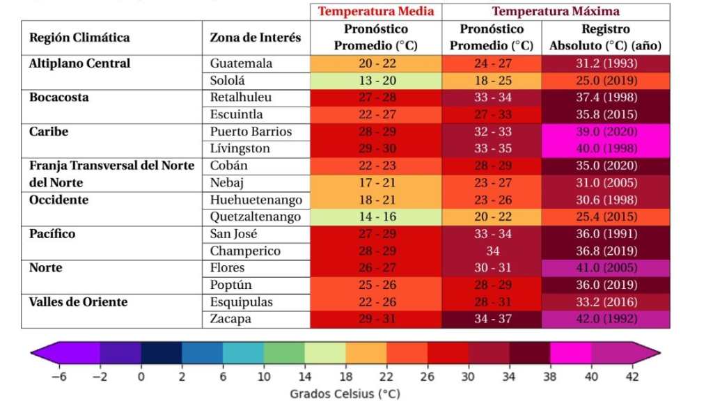
However, although temperatures have begun to decrease with the advance of the rainy season, Insivumeh predicts that during the first week of June maximum temperatures between 34 and 38 °C in Peténhe Caribbeanthe Northern Transverse Strip, East and the region of Peaceful.
Meanwhile, for the Central Highlands and West values are expected between 22 and 30 °C.
The Insivumeh had already confirmed a heat wave on April 29, when three continuous days with extreme temperatures were recorded. In that period, Zacapa, Petén and San Marcos registered between 38 and almost 40 °C.
Extreme temperatures in Zacapa
Preliminary weather records for May 2026 reflect that La Fragua, Zacapa, experienced some of the hottest conditions in the country.
During that month, the average maximum temperature was 39.2 °C. But the highest values reached 42.6 °C on May 2 and very similar, days later, 42.4 °C on May 7evidencing the intensity of the heat that mainly affected the east of the national territory.
These values were above the usual averages and were recorded in a context of high temperatures in much of the country.
The thermometer parameters were not the only thing that generated the perception of a warmer environment. Weather reports show there was a decrease in relative humidity, increased sunshine and reduced cloud cover for several days.
There were also variations and wind speed tended to decrease in different regions, conditions that all together have favored a greater thermal sensation and one more intense exposure to solar radiation.

The capital also recorded hot days
Although the most extreme temperatures were concentrated in the east of the country, Guatemala City also experienced warm conditions during May.
Records in the capital show that in the Insivumeh Central Stationlocated in the zone 13the average maximum temperature was 29.4 °C.
The data show that, despite the gradual establishment of the rainy season, maximum temperatures remained high for much of the month. Of the 27 days with records available, nine reached or exceeded 30°C.
The highest temperature was reported from 32.6 °C on May 18according to the institution’s reports that are then re-verified for historical measurements.
Other days with high temperatures were May 7, when they registered 31.5°C; on May 19, with 31.2°C; and the days May 11, 14, 16, 21, 22 and 23, when the values ranged between 30.1 and 30.9 °C.
According to historical data from Insivumeh, one of the highest temperatures recorded in Guatemala occurred in May 1998, when the thermometer in Zacapa reached 43°C.
June will have rain, but persistent heat
Insivumeh’s June climate outlook indicates that the month will be marked by the rainy season, although with accumulated below normal in some exceptional regions, temperatures above average and the development of cyclonic season in the Atlantic.
The report predicts that the highest rainfall accumulations will be recorded between the second and third week of June in much of the national territory.
Furthermore, international models show a transition towards conditions associated with El Niño with a probability of 98%. Although the climate perspective does not directly attribute the predicted scenarios to this phenomenon, both elements coincide within the projections for the coming weeks.
Despite the expected increase in rainfall, Insivumeh predicts that temperatures continue above normal values in different regions of the country during June.
Other related news: