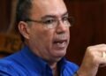
SOMETIME between August and October, people should begin to see drier conditions around the country, according to National Weather Service assistant director Kasis Inape.
“The dry season has started and some provinces are picking it up because they have been experiencing dry weather since November last year,” he said.
“Those provinces are the ones seeing more dry conditions already.”
Inape said some provinces were still having rain however.
“The dry season has already started.
“The normal cycle is from April to September.
“We’re also seeing that we have El Nino coming on board which will make it much worse because it’s happening together with the dry season.”
He said that scientists were predicting a “super El Nino”.
“El Nino and La Nina are normal climate variability events that happen every five to seven years. Now it’s becoming more frequent and more intense,” Inape said.
He explained that the factor that “drives El Nino is the moisture”.
“The oceans are a good conductor of heat.
“They capture the energy in the oceans and slowly release it.
“That’s why you have thunderstorms, tropical cyclones.”
Inape said they had been observing in the past five years the warmest year on record, meaning that a lot of heat had been stored in the ocean.
“When you have a lot of heat in the ocean, that energy has to go somewhere else. That creates disasters,” Inape said.
“As long as the ocean depth is bigger, it will take a longer time for it to dissipate and produce all these impacts.” He added that most of the models were showing the onset of a “super El Nino”.