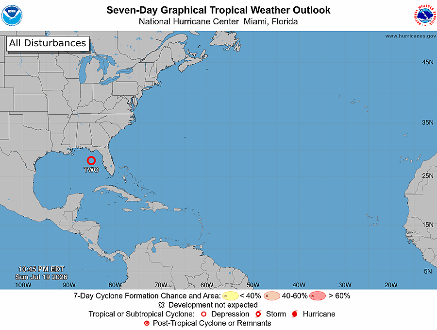


Invest 91L off the Florida coast in the Gulf of America became better defined overnight and formed into Tropical Depression Two July 19, according to National Hurricane Center forecasters.

The system, about 180 miles south-southeast of Panama City, has a high chance of becoming a named storm.
A Tropical Storm Watch has been issued for Florida from Ochlockonee River to the Alabama border.

“The depression is expected to gradually strengthen and could bring tropical storm conditions to portions of the Florida Panhandle beginning late Monday, where a Tropical Storm Watch has been issued,” according to the National Hurricane Center’s forecast discussion. “Interests in Alabama, Mississippi, Louisiana, and Texas should monitor the progress of this system, as watches could be required for portions of that area over the next day or two.”

The depression is expected to produce rainfall amounts of two to four inches with locally higher totals around eight inches through Friday along the Gulf Coast and adjacent inland locations from western Florida to the Middle Texas Coast.
In other words, be prepared for heavy rains and possible flooding.

The second named storm of the 2026 Atlantic hurricane season will be Bertha.
Here’s what forecasters are seeing as of 8 p.m. Sunday, July 19, 2026:


It’s unlikely this system will be come a hurricane because of Saharan dust and strong wind shear, but it could become a tropical storm, forecasters said the morning of July 19.
“Flash flooding from slow-moving or repeated downpours looks to be the biggest threat from the tropical rainstorm, even if it does not fully develop into a tropical depression or storm,” AccuWeather Meteorologist Alex Duffus said.

The National Hurricane Center on its tropical outlook map as of 5 p.m. July 19, was Tropical Depression Two:
The center of Tropical Depression Two was located near latitude 27.5 North, longitude 85.0 West. The depression is stationary. A very slow northwestward or north-northwestward motion is expected during the next day or two, followed by a turn toward the west.
Get the Daily Briefing newsletter in your inbox.
Start your day with the morning’s top news
Delivery: DailyYour Email
On the forecast track, the depression will move near or along the northern Gulf coast during the next several days.
Maximum sustained winds remain near 30 mph (45 km/h) with higher gusts. Gradual strengthening is forecast, and the depression is expected to become a tropical storm on Monday, the latest advisory states.
Location: 27.7 degrees N, 85 degrees W
Direction: The depression is stationary.
Min pressure: 1008 mb
What impacts could Florida feel this weekend?

Rainfall looks to be the biggest threat regardless of development or official designation, DaSilva said.
“While rainfall will be welcome across portions of the Florida Panhandle due to an ongoing drought, the flooding risk can be increased due to dry soil. This dry, hard soil can allow the water to run off instead of being absorbed right away,” DaSilva.
Advertise with the mоѕt vіѕіtеd nеwѕ ѕіtе іn Antigua!
We offer fully customizable and flexible digital marketing packages.
Contact us at [email protected]