- Mexico City is sinking by around 24 centimeters annually, and in some places around two centimeters per month, according to NASA.
- The cause is the massive groundwater extraction in the former lake bed, which means that buildings are visibly crooked and a water crisis arises.
- The lowering also endangers infrastructure such as the subway and cables.
- New satellite data should capture the problem more precisely.
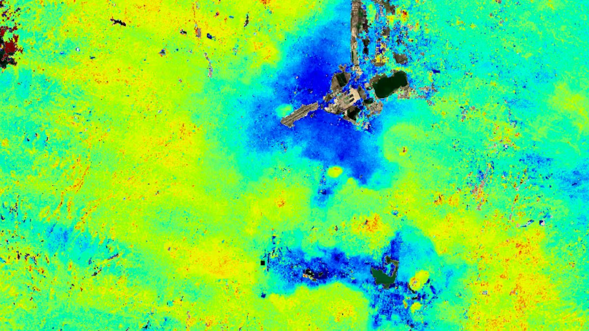
Drops around 24 centimeters the metropolis of Mexico City every year. In places such as the international airport and the Ángel de la Independencia monument, the US space agency NASA recently recorded an average subsidence of two centimeters per month. In hardly any other city in the world does this happen at such a rapid pace.
That’s why Mexico City is sinking
The Mexican Capital Region is one of the most extensive and populated metropolitan areas in the world, covering an area of 7,800 square kilometers and was built on an ancient lake bed.
Because so much groundwater was extracted over the years and the city expanded so much, the aquifer shrank dramatically. In fact, this is why Mexico City has been sinking for more than a century, and many monuments and older buildings – such as the cathedral, whose construction began in 1573 – are visibly leaning to one side. Reducing groundwater levels have also contributed to a chronic water crisis that is expected to worsen.
12 meters deeper: damage is the result
In total, the city has sunk by twelve meters in less than 100 years, says Enrique Cabral, a geophysicist at the National Autonomous University of Mexico. This could damage important urban facilities, such as the subway, the sewage system, drinking water pipes and roads. This is “a very big problem” for the capital region.
Latest satellite data shows “the full extent of the problem”
NASA’s estimates are based on measurements taken between October 2025 and January 2026 by a powerful satellite called Nisar. This satellite can track changes on the Earth’s surface in real time and is a joint initiative between NASA and the Indian Space Research Agency. Capturing details from space tells us something about what is actually happening beneath the Earth’s surface and documents the changes, says Nisar scientist Paul Rosen. “You can see the full extent of the problem.”
Have you ever been to Mexico City?
His team hopes that over time they will be able to zoom in even more on specific areas and one day take measurements for each individual building. Researchers aim to use the technology globally to track natural disasters, changes in fault lines, the effects of climate change in regions like Antarctica, and more. This could also serve to improve warning systems, for example in the event of volcanic eruptions.
Data gives hope
For Mexico City, the Nisar dates meanThat the subsidence can be studied more closely and the worst effects can be mitigated, says geophysicist Cabral. For decades, the government largely ignored the problem and only stabilized the foundations beneath monuments like the cathedral. But more is now being invested in research, says Cabral. “In order to defuse the situation in the long term, you first have to understand it.”
Don’t miss any more news
With the daily update you stay informed about your favorite topics and don’t miss any news about current world events.
Receive the most important things, briefly and concisely, directly to your inbox every day.

Fee Anabelle Riebeling (fee) has been working for 20 minutes since 2014. She is deputy. Head of Knowledge, History & Digital and Head of the Fact Check & Verification expert committee.