In the afternoon, the residents started sharing the captured images of the storm and its effects on social networks, and forecasters around 5 p.m. gave the reassuring news that the main band of the storm had moved away.
“According to the data at 5:45 p.m., rain clouds are moving in some areas of the country, in some places they are accompanied by thunderstorms. The main band of storms has already left Lithuania, according to meteo.
In the next few hours, only isolated short-term rain clouds will pass in places, there will be thunderstorms in some places,” the meteo announced.
At that time, residents shared impressive images of the storm moving through the country in the “Weather Enthusiasts” Facebook group. Powerful gusts of wind, heavy rain and dark storm clouds covering the sky with gray fog were recorded near Lentvaris.
Heavy rain, falling ice and stronger wind were also reported in Vilnius. Residents shared photos on social networks showing massive storm clouds gathering over the capital. Forecasters urged residents to stay alert and follow the latest information on changing weather conditions.
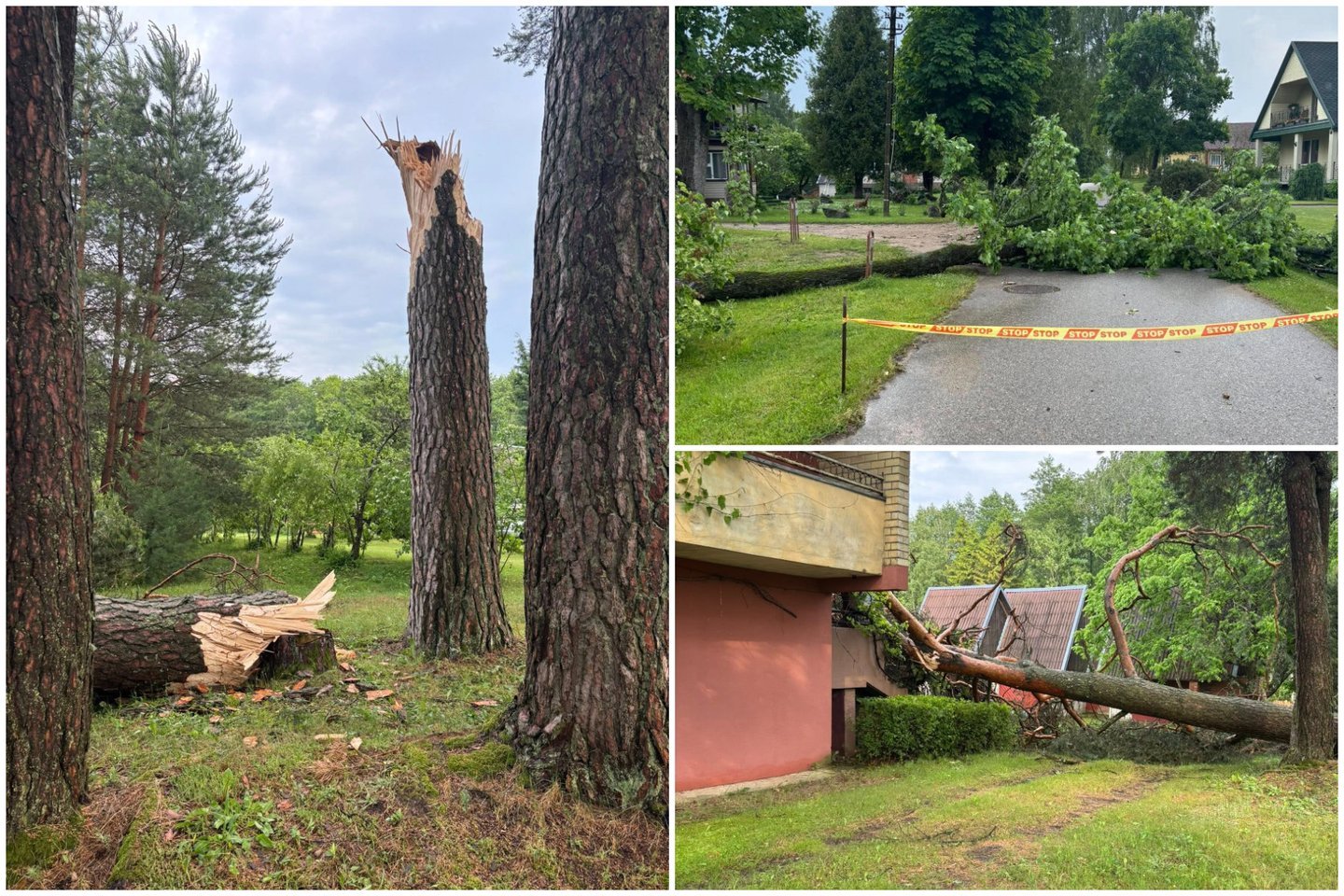
In the afternoon, images from Utena, Molėtai also began to flow. It can be seen that there was a strong wind, which in some places overturned the trees, and rains. And here, near Šalčininkai, considerable hailstones were also recorded.
The storm also severely damaged the village of Gimžiškių in Utena district. According to the resident, many fir trees were broken here, and the village of Sudeikiai was also affected.
The “Weather and Climate in Lithuania” Facebook page announced that another mass of rain and thunderstorms was heading towards the capital from Belarus.
“One massif of rain and thunderstorms is currently near Vilnius and already in the city itself, the other is just moving away from Belarus. It can be seen very well in the radar images (updated every 5 minutes).”
Meteorologist Gytis Valaika reported in the Facebook group “Weather and climate in Lithuania” that two extremely powerful storm clouds had formed in a very short time.
“Two ‘mushrooms’ emerged in a very short period of time. Now they are slowly becoming one. The temperature of the cloud tops reaches up to -63…-65 °C. Such cold tops of spherical rain clouds occur rarely and only in the warm season,” the meteorologist wrote at 3:30 p.m.
According to him, such clouds can bring not only very heavy rain, but also large hail, which can cause damage to residents’ property and crops. In certain cases, such storms can also form tornadoes.
The meteorologist drew special attention to the northeastern part of Lithuania, whose residents were advised to watch the sky and follow the latest information about the changing situation.
“Northeast, watch the sky,” warned G. Valaika.
ESO: 10,000 people were left without electricity due to the storm. population
On Thursday, as storm clouds moved over Lithuania and forecasters predicted squalls and hail, about 8 thousand residents were left without electricity, according to the data of “Energijas skirstamo operatorius” (ESO).
3:20 p.m. ESO representative for public relations Rasa Juodkienė Eltai said that up to 6 thousand disorders, but the numbers are changing rapidly. 3:40 p.m. On the ESO disconnection map, the number of customers disconnected due to malfunctions reached more than 8.2 thousand.
5 p.m. the number of residents without electricity reached 10 thousand, and at 9 p.m. there were 7.8 thousand without electricity. population. 11 p.m. there were still 5.5 thousand such residents.
According to R. Juodkienė, most disturbances were recorded in Šalčininkai and Molėtai.
“The forces have been assembled since yesterday morning, we have significantly increased the number of brigades, dispatchers and other employees, who are all focused on eliminating the disturbances as soon as possible,” R. Juodkienė told Eltai.
“At the moment, we are recording the most disturbances in the Vilnius and Utena regions, so Molėtai and Šalčininkai are two essential points here,” she said.
According to the representative of ESO, there have been no recorded failures of the electricity network so far.
“We are also collecting this information according to forecasters’ forecasts (…) the storm, the squall is still forming, so we have not yet recorded any special events,” she said.
The PAGD representative urges not to panic and to follow the recommendations
Firefighters and rescuers had already received about 20 reports of trees downed by the storm on Thursday afternoon.
“Utena district, Molėtai, Zarasai, Utena county prevails. In Molėtai district, a tree fell on the roadway, and in Zarasai, a tree fell on wires,” Sonata Kukienė, a representative of the Fire Protection and Rescue Department, told Elta.
Some time ago, notifications about the approaching storm were sent to a part of the Lithuanian population. After receiving them, according to the representative of the Fire Protection and Rescue Department (PAGD), Paulius Rinkevičius, it is important not to panic and follow the recommendations.
“Due to the mentioned changes in the weather today and the values that can reach the natural level, a warning message was sent to the residents of Vilnius, Panevėžys and Utena counties. After receiving this message, it is important not to panic, not to get lost (…). If we are at home, let’s close the windows, roofs. If we have a courtyard, a terrace, a balcony and there are unsecured things, let’s fix them. If we have a car, let’s not park it under trees, under electric wires. It’s a very important moment to take care of your loved ones. If there are people who can’t take care of themselves, the people closest to them should take care of them,” said P. Rinkevičius.
“It is necessary to charge mobile phones (…), because during a storm, the power supply may be interrupted for some time, so it is important that the devices are charged (…). If we are in a safe room and we have scheduled meetings, let’s postpone them or cancel them altogether, postpone them, let’s carry them out when the danger is no longer there,” said the PAGD representative.
In addition, according to him, it is very important to follow the reports, recommendations and published news of the relevant services.
As announced, strong rains with thunderstorms, as well as gusty winds are forecast in Lithuania on Thursday. Hail is also possible in many places, mainly in the eastern part of Lithuania.
According to forecasters, the wind will change direction during the day, its gusts will reach 15-20 m/s in many places, and it will strengthen to 23 m/s in some places. The highest temperature will reach 14-19, in Eastern Lithuania – 20-25 degrees.