
Neighboring countries are experiencing a stormy passage of a cold front in these hours, which is bringing important moisture into Central Europe. According to information from the iMeteo portal, the precipitation field stretches across a large part of the continent, while the most significant totals, locally from 20 to 50 mm, fall mainly in Germany, the Czech Republic and Poland. For the arid regions there, this is a key moment that has the potential to at least partially alleviate the critical soil moisture deficit.
The situation in the Czech Republic is extremely dynamic. The Czech Hydrometeorological Institute (ČHMÚ) issued warnings against strong storms, which hit the western part of the country with full force during the evening. The most serious situation was reported in Karlovy Vary and Ústí Region, where meteorologists warned of wind gusts of up to 60 km/h. A prominent shelf cloud was even formed at the head of the storm line, which heralded the arrival of torrential rain. In Rokycany, the stations measured up to 36 millimeters of precipitation accompanied by hail. Czech meteorologists in the affected locations warn against flooding of smaller streams and flooding of low-lying places, such as basements and underpasses.
In the north of Bohemia, however, rain also has a deeper security significance. ČHMÚ confirmed with relief that it has finally started raining in the Czech Switzerland National Park. It is extremely important news for the area, which has faced again in recent days a destructive flame in difficult-to-access terrain. Slovakian firefighters and our helicopters were also deployed during the liquidation of this fire. Natural help in the form of rainfall is the best possible scenario for tired response teams when definitively extinguishing hidden outbreaks.
 Read more The map of Slovakia lights up red, the situation is not going to improve any time soon
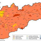
Slovak fields, however, remain parched for now. Currently drought maps they show alarming values in most of our territory, and the lack of moisture has a negative effect on the condition of the crops. When will it change? The forecasts of SHMÚ already indicate the first sign of a turnaround. Precipitation activity associated with the mentioned front should begin to manifest gradually in our territory. Although the main wave is still bypassing us in these hours, the first storms are expected already on Thursday afternoon. Unlike the previous dry days, they should be locally more intense and affect several districts.
However, even before we are drenched in rain, we must beware of stormy weather on our mountains. From midnight today until six o’clock in the morning, there is a first level warning against strong winds. This applies mainly to the districts of Banská Bystrica, Brezno, Poprad and Liptovský Mikuláš. In positions above 1,500 meters, meteorologists expect a gale that can reach a speed of up to 135 kilometers per hour in gusts, which poses a danger for any high-altitude activities.