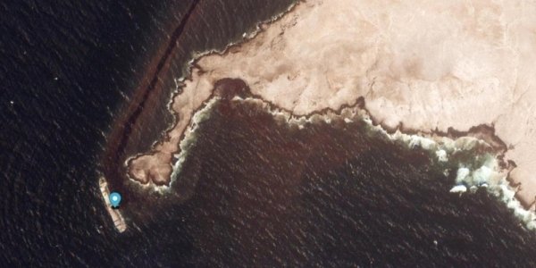
The efforts include a comprehensive national response that combines technical measures to address the oil spill, secure the vessel, and conduct ongoing environmental monitoring and assessment to mitigate the risks of the incident, protect the marine environment, and ensure navigational safety.
Impact on desalination plants
Dr. Abdullah bin Ali al Amri, chairman of the EA, said that the results of environmental monitoring, surveillance, and assessment accurately and reliably indicate that there is absolutely no cause for concern regarding vital facilities such as desalination plants.
EA said that it is monitoring the incident through an integrated system of environmental monitoring, assessment, and evaluation. This system involves specialized national technical teams and utilizes modern monitoring methods, satellite imagery, environmental models, and field surveys to continuously assess the environmental situation, track the movement and spread of the oil pollution, and identify priority areas for response and protection efforts.
EA indicated that the environmental response to the incident is based on updated scientific and technical data and the results of on-site monitoring, while continuing to assess potential risks to the marine environment, coastal areas, and environmentally sensitive habitats.
Areas affected
EA said that the latest monitoring and technical analysis, including satellite imagery analysis, showed the continued presence of oil pollution in the marine area associated with the incident. An oil slick covering approximately 390 sq km was detected, extending northeast of the Hallaniyat Islands towards the mainland coast, reaching a point approximately 7 kilometers from the shore.
She indicated that monitoring and image analysis showed the slick continuing to move along a similar path, with its observed extent reaching around 449 km
According to current assessment and modeling results, the slick is generally moving northeast, with projections indicating an advance of approximately 121 kilometers within the next 48 hours, based on prevailing marine and atmospheric conditions at the time the model was developed. She emphasized that this result represents a scientific prediction and not an actual observation, and that environmental models are affected by any changes in wind, currents, and marine conditions.
Moving towards Duqm
The analysis results showed that the thickest parts of the pollution may be moving towards the entrances of Ras Madrakah, necessitating continued intensive monitoring of marine and coastal areas of environmental priority. It was confirmed that the observed area of the slick, approximately 390 sq m, does not represent the quantity of oil spilled, but rather the geographical area where the pollution appeared according to the latest monitoring and analysis.
Quantity of oil spill
It was explained that the relationship between the slick area and the quantity of oil spill cannot be directly determined, as it depends on several technical factors, including the thickness of the oil layer, the nature of the oil, the degree of dispersion, the movement of ocean currents, wind direction and speed, waves, and marine conditions.
It was noted that the slick’s area, shape, and location are subject to change from one monitoring to another due to movement, dispersion, and natural dispersion. Therefore, the figure is treated as a technical reading related to the time of monitoring and not a fixed number.
This supports timely and appropriate decision-making. Data is continuously analyzed to determine whether the observed spills represent continuous accumulations or scattered areas resulting from dispersal and spread.
The Environment Agency affirmed its commitment to publishing official updates on the environmental status of the incident as developments warrant, ensuring the provision of accurate and reliable information to the public and media. It emphasized the importance of obtaining information from official sources and refraining from circulating unverified figures, maps, or estimates.
Environment Agency of Abu Dhabi (EAD)
The Environment Agency of Abu Dhabi (EAD) affirmed that protecting biodiversity, marine habitats, and environmentally sensitive areas is a top priority in addressing the incident. Efforts are underway to identify areas most vulnerable to impact and link them to the pollution’s movement paths, prioritizing areas of high environmental value and sensitivity.
Assessment and monitoring efforts encompass sensitive marine areas, islands, and habitats, including coral reefs, turtle nesting areas, marine habitats, and coastal areas of environmental importance. Risk assessments are continuously updated based on changes in the location, extent, and direction of the pollution’s movement.
EAD emphasized the importance of distinguishing between actual observations and projections or modeling scenarios. Some data regarding the size, path, extent, and potential environmental impacts of the pollution may change as monitoring and analysis continue. Official information is updated according to the latest documented technical findings. The EAD stressed that any circulating estimates regarding the amount of oil spilled are not final or reliable figures unless based on a documented and approved technical assessment from the relevant authorities.
This includes identifying the sources of the leak, developing appropriate technical solutions to mitigate the ship’s deterioration, and addressing the leak sources, including the safe transfer of the oil cargo. The plan also includes salvaging the ship’s hull while ensuring compliance with maritime safety requirements.