The extension of Line 2, phase “A”, the next in the Panama Metro Master Network, is especially timely given the upcoming opening of Line 3 and the need to consolidate a more integrated public transportation network in the city. Its construction will consolidate the access of the Panama Metro to the urban center of Panama City from the north (Line 1), east (Line 2) and west (Line 3) to its main areas of employment, education, commerce and services.
How will it transform mobility and the connection between neighborhoods, universities and employment centers? Can it become an opportunity to rethink Tumba Muerto and beyond with Manuel E. Batista and Domingo Díaz roads as an urban corridor?
The route follows the axis of an important urban corridor, the Dead Tomb road. The term Tumba Muerto appears in La Estrella de Panamá publications from 1912 and 1913 to identify a place close to the old Camino de Las Sabanas. Recovering and understanding this territorial memory is also important in the face of attempts to replace popular names deeply rooted in the city.
This stretch of road, also named Ricardo J. Alfaro road, has been progressively densified around a road infrastructure that depends on a single main axis. On both sides, the road network is intricate and poorly connected: there are practically no continuous streets capable of functioning as parallel axes to the Tumba Muerto road. Towards the north, the residential fabric is not particularly extensive, conditioned by the old Canal Zone and the Metropolitan Natural Park. There are clearly defined centralities, such as El Dorado and, more recently, Condado del Rey.
The result resembles a herringbone pattern, where numerous local streets end up flowing into a single artery. This situation poses a challenge for new stations. Each can become a kind of funnel towards which cars, taxis, pedestrians and buses converge. Therefore, building the metro line and simultaneously intervening in the road network, sidewalks, pedestrian crossings and feeder routes would bring great additional benefits in urban terms.
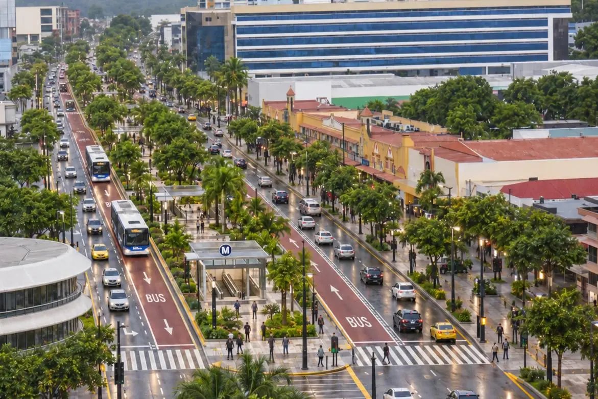
The width of the road and the central median, added to the three traffic lanes in each direction, facilitate the incorporation of an exclusive road for buses that would complement Line 2 without significantly affecting road operations. The space already exists, which simplifies the intervention, unlike the project proposed for Via España. Furthermore, the Tumba Muerto–Manuel Espinosa Batista axis preserves a large central space whose landscape potential has been wasted. It is not the competition of two systems but the integration of two modes of transportation that would improve integration with buses and different feeder routes. A redesign of the street would allow the incorporation of green areas and considerably improve the urban experience of the corridor.
The first big challenge appears at the El Bosque and Condado del Rey stations. Its importance does not depend solely on the railway line, but on the ability to connect the neighborhoods of Limajo, Residencial El Bosque, Linda Vista, Altos de Panamá and Condado del Rey with the nearby sectors of San Miguelito, such as the neighborhoods 9 de Enero, Los Andes 1 and Los Andes 2 in the Amelia Denis de Icaza district, district of San Miguelito; which are partly also served by Line 1 with the Los Andes and Pan de Azúcar stations.
Here, feeder routes and the right of way acquire special importance for the operation of public transport routes. The bus system should connect stations on different lines and cross residential neighborhoods to solve the so-called last mile. Not all passengers can walk to a station, especially in sectors with rugged topography, discontinuous streets and few pedestrian or public transportation connections. It is the problem of urban continuity between Panama City and San Miguelito and even within the district itself. Administrative boundaries and neighborhoods with different socioeconomic profiles become physical barriers. The city must connect neighborhoods that have been inherited from different urbanization processes.
With the Universidades station there is the opportunity to integrate into the metro system the university cluster that has been consolidated throughout Tumba Muerto and that impacts the daily mobility of students, teachers and workers, such as UTP, USMA, UIP, Universidad Latina and Universidad de Panamá. Why not design among the academic teams of private institutions a master plan for the design of a single “university campus”?, which emphasizes public spaces, pedestrian safety and green areas. It also opens the possibility of developing student housing and its complements around the station.
El Dorado has established itself as the main centrality of the town of Betania, a commercial and residential destination. The arrival of the metro also offers the opportunity to build a civic center that accompanies commercial activity and reorganizes access to the interior of the district’s neighborhoods through a distribution center for public transport passengers. While the University of Panama Station It will facilitate access to the Octavio Méndez Pereira campus of the University of Panama as well as sectors such as Brooklincito in Curundú, access to the Transístmica highway and the southern sector of the Argentina highway in the El Cangrejo neighborhood.
Line 2A incorporates a station in the area of Calle 50, on Aquilino de la Guardia Avenue, offering direct access to one of the main commercial, financial and employment corridors of the city. From there connectivity extends to Paitilla. This section will allow connecting different cores of the urban center and strengthening the integration between the existing and future lines of the system.
It is worth remembering that the branch to the airport was conceived so that Line 2 could operate with two origin/destination points at its eastern end: one towards Nuevo Tocumen and the other towards the air terminal. In a single trip from Paitilla it will be possible to reach the Tocumen International Airport, Nuevo Tocumen and, with the future extension, to Felipillo. The extension of line 2 proves that the city needs an urban intervention plan where transport, public space and urban development move together towards more efficient mobility and a more modern and connected city.