After the recent afternoon rains in the National DistrictSanto Domingo Oeste and Puerto Platathe geologist engineer Osiris of Leon He assured that these showers are produced by the cumulonimbus cloud that is created vertically and taking the water evaporated from the sea during the afternoon and on warm days.
The clouds that cause the greatest amount of rain where they develop are cumulonimbus, due to their vertical rise, the sea water evaporates and rises, increasing its size, forming a dense and threatening cloud, associated with intense storms, hail, strong winds and, sometimes, tornadoes.
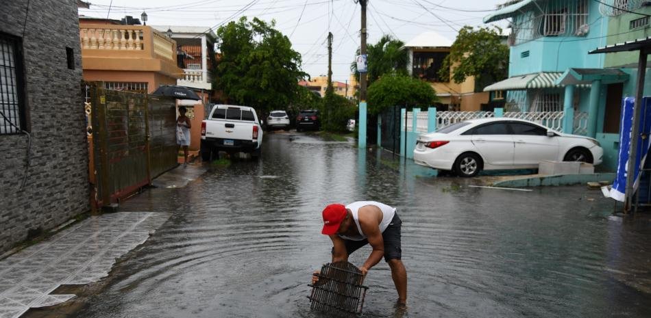
These clouds are created in the evening hours on the warmest days and in coastal areas such as the National District, Santo Domingo Oeste, Puerto Plata and La Altagracia; These territories are more prone to the creation of intense torrential rain and flooding due to increasing urbanization.
“Cumulonimbu is a cloud that, in fact, pilots are very afraid of, because it is a cloud that goes up, not to the sides, and then that cloud is always very loaded with water vapor,” he explained.
The academic of the Academy of Sciences of the Dominican Republic He stated that the stagnation of waters in coastal areas of the country is not due to saturation in the soil, but because the drainage is covered by urban planning and has not been adapted to the growing population, which will cause a number of years depending on the rate of passing and climate change to take its course.
“Urban drainage must be multiplied by 4 and 5 to drain up to 125 millimeters of rain per square meter per hour, since it is not that the soils are saturated, as is often repeated, because in reality it is that the primary pores of the coral limestone rock of the National District, Puerto Plata and La Altagracia are blocked by urban planning,” he highlighted to this medium.
He said that, with the growth of urban planning such as buildings, hotels, streets, avenues, sidewalks and parking lots, urban developers did not install alternative secondary drainages to the natural and primary drainages that were blocked. That’s why the rains that flooded the National District, Santo Domingo Oeste and Santo Domingo Nortewhere there are only impermeable clays and loams that prevent rainwater infiltration.
De León said that torrential rains were falling on Santo Domingo and Puerto Plata, and that they have generated major flooding; They constitute a regional problem that responds to a meteorological pattern altered by climate change that increases global temperature and increases the capacity of the atmosphere to retain water vapor that rises from the neighboring sea during the afternoon hours of intense solar radiation, and that vapor is concentrated vertically upward, facilitating rapid condensation processes in the troposphere, and that is why it rains torrentially, in the same place, as occurred during the early hours of Wednesday, April 8, 2026.
“Because it is very hot, there is a lot of evaporation of seawater because solar radiation acts directly on the surface of the sea,” he said.
The torrential rain in the National District and Santo Domingo Oeste recorded 440 millimeters of rain in less than 7 hours. As an effect of climate change, in the province of Puerto Plata the bridge over the Camú River collapsed, on the town’s tourist highway, near the community of Tubagua, south of Sosúa.
Precautions to avoid flooding
The geological engineer recommended that the authorities maintain 24-hour surveillance of the alert systems, monitoring the Doppler radars and rain gauges to know when the rains in a certain place are reaching the flash flood threshold, and immediately proceed to warn.
“Urban drainage should not continue to depend on sewers designed and built when there was still no talk of climate change. Now we must multiply the capacity of rapid drainage to drain 100 to 150 millimeters of rain per square meter per hour, because today the rains are fast, and in 6 hours the rains that previously fell in 6 months fall, and these variables must necessarily enter into the equation of the solution and the effective response that the population expects,” he expressed.
In addition, he suggested the construction of free underground drainage galleries, French drains, large diameter wells (minimum 2 meters), filled with thick gravel for rapid vertical drainage to the water table.
Also, each new urbanization project must present a sectoral storm drainage system prior to its approval by the municipal chapter house and by the Ministry of Housingtaking advantage of the topographically lowest portion of the sector as a drainage area.
In order for building developers to improve construction quality, he suggested that they provide flood certificates that have a policy against subsidence. In the case of areas already affected, mark them so that the corresponding measures can be taken.