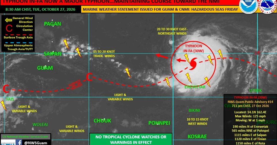
Typhoon In-fa as of Tuesday morning was a major Category 3 typhoon tracking to pass through the Commonwealth of the Northern Mariana Islands later this week, according to the National Weather Service.
As of 7 a.m. Tuesday, In-Fa was located 190 miles north of Enewetak in the Republic of the Marshall Islands, 1,180 miles east of Guam and was “nearly-stationary” moving westward at 1 mile per hour. According to forecasters, maximum sustained winds were at 125 miles per hour.
On Monday, the typhoon underwent a period of rapid intensification, growing from a Category 1 typhoon to a powerful Category 4 typhoon with maximum sustained winds of 130 mph by the evening.
NWS said the typhoon slightly weakened Tuesday morning down to a Category 3, likely due to being nearly-stationary by an upwelling of cooler water at the surface. The weather service said In-fa is likely to pick up forward speed, moving west, then gradually turning toward the west-northwest as it begins to steadily strengthen.
In-fa could evolve into a super typhoon by Thursday and maintain that intensity as it passes near or over the CNMI island of Pagan on Friday, though there are no tropical storm or typhoon watches or warnings in effect at this time.
NWS lead meteorologist Ken Kleeschulte said the center of the typhoon is expected to move barely south of Pagan.
Tracking data puts Saipan just outside the southern edge to the cone of uncertainty, which means In-fa could drop southward and pass close to the island. But forecasters said it’s increasingly unlikely.
“Numerical forecast model guidance shows strong agreement for a passage between Anatahan to the south and Agrihan to the north,” NWS said. “While the forecast prognosis looks fair for Saipan, residents across all islands of the CNMI should continue to watch the progress of In-fa closely in the coming days and be ready to take action if that becomes necessary.”
For Guam, residents shouldn’t expect to see much as In-fa makes it approach to the Marianas according to Kleeschulte. The island could see more showers and increased winds and gusts of up to 25 to 30 mph, but those in Saipan and Tinian are expected to feel it more.