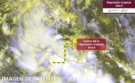
The Tropical Depression Two-E intensified during the early hours of this Monday at Tropical Storm Borisreported the National Meteorological Service (SMN), who warned abouttorrential rains, strong winds and high waves in various entities of the country.
According to the agency, at 3:00 a.m. central Mexico time, the center of Boris was located approximately 135 kilometers southeast of Acapulco and 80 kilometers southwest of Punta Maldonado, Guerrero, with maximum sustained winds of 65 kilometers per hour and gusts of up to 85 km/h.
The circulation of the system will continue to favor torrential rains between 150 and 250 millimeters in western and coastal regions of Guerrero; heavy rains from 75 to 150 millimeters in the southeast and coast of Michoacánas well as in the southwest of Oaxaca; in addition to very heavy rainfall in the south of Jalisco and in Colima.
Read also Rainy season 2026: how to prevent waterlogging and flooding?
Likewise, wind gusts of 70 to 90 km/h are expected on the coasts of Guerrero and western Oaxaca, while winds of 50 to 70 km/h could be recorded in Jalisco, Colima and Michoacán.
Regarding waves, the SMN predicts heights of between 4 and 5 meters on the coasts of Guerrero and western Oaxaca, as well as 3 to 4 meters on the coasts of Jalisco, Colima and Michoacán.
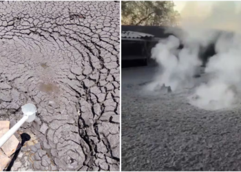
Given these conditions, the authorities warned about the risk of landslidesincrease in the levels of rivers and streams, overflows and flooding in low areas, for which they urged the population to remain attentive to official warnings and follow the recommendations of Civil Protection.
Read also Rainy season in Mexico; avoid getting wet with this automatic folding umbrella
At the moment The prevention zone remains active due to the effects of tropical storm winds from Lagunas de Chacahua, Oaxaca, to Técpan de Galeana, Guerrero.
Hours later, at 6:00 in the morning, the National Meteorological Service reported that Boris will continue to interact with a trough at medium and high levels of the atmosphere, low pressure channels and atmospheric instability, which will maintain a rainy season over much of the national territory.
The SMN predicts intense to torrential rains in Jalisco, Colima, Michoacán, Guerrero, Oaxaca, Chiapas, Veracruz, Puebla, San Luis Potosí and Tamaulipaswhere significant accumulations capable of generating floods, landslides and river flooding could be recorded.
Read also “My job is going to die,” says ball repairman
In entities of the northeast, east, center, west, south and southeast of the country, including the Valley of Mexico, heavy to very heavy rains will persist during the day.
On the other hand, the displacement of tropical wave number 5, in combination with the entry of humidity, will cause heavy rains in the Yucatan Peninsula.
Despite the rainfall, the hot to very hot environment in much of the Mexican Republic. The heat wave will prevail in regions of Sonora, Chihuahua, Durango, Sinaloa, Nayarit, Jalisco, Colima, Michoacán, Guerrero, Oaxaca and Chiapaswhere high temperatures will remain for the next few hours.
The authorities recommended that the population take extreme precautions, especially in coastal areas and regions vulnerable to flooding, as well as avoid crossing river beds, streams or flooded roads.
L.L.